1960s Maps of Flomaton, Alabama
Explore 3 historic maps of Flomaton from the 1960s. These maps offer a rare glimpse into what life looked like during the 1960s — showing old roads, neighborhoods, homes, and landmarks that have changed or disappeared over time.
Whether you're researching your family's past, planning a metal detecting trip, or studying how Flomaton's landscape evolved across the 1960s, these high-resolution maps are a powerful tool for exploring the history of this region.
- Focus on a specific era: All maps on this page are from the 1960s, giving you a focused view of this time period.
- See what’s changed: Compare century-old streets, trails, and buildings to today's modern landscape using overlays and satellite layers.
- Research with precision: Use these maps for genealogy, historical research, land use analysis, or educational projects.
- View, download, or print: Maps are fully viewable online in high resolution, and can be downloaded or printed for your own records.
Start exploring Flomaton's history through authentic maps from the 1960s. This is your window into the past.
Flomaton, AL maps
(3)- 1960 Map of Pensacola
 1960 Pensacola1960 Print · USGSThe Florida Panhandle and Alabama's eastern shore are shown during a period of rapid military and coastal growth. Genealogists and historians can trace the mid-century footprints of Warrington, the Pensacola NAS (Chevalier), and the Blackwater River timber lands.
 - 1960 Map of Pollard, 1961 Print
 1960 Pollard1961 Print · USGSThe Alabama-Florida borderlands come to life in the early 1960s, showing the intersection of the Conecuh River and the LOUISVILLE AND NASHVILLE railroad. Researchers can locate family landmarks like Hollywood Cem, McCall Sch, and the Catawba Springs Ch.3 unique versions available
 - 1960 Map of Flomaton, 1961 Print
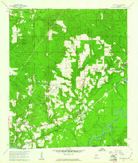
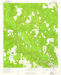 1960 Flomaton1961 Print · USGSThe Alabama-Florida borderlands near the turn of the 1960s were shaped by the Escambia River and the vital rail junctions at Flomaton. Researchers can trace rural genealogy and industry through sites like Moyeville, Hammac Cem, and the extensive Old Railroad Grade.2 unique versions available
End of results
Showing maps 1-3 of 3
Top cities near Flomaton
- Atmore historical maps
- Brewton historical maps
- East Brewton historical maps
- Century historical maps
- McDavid historical maps
- Jay historical maps
See more
Frequently asked questions
- What are the different types of historical maps available for Flomaton?
- What is the oldest map of Flomaton?
- Where can I purchase historical maps of Flomaton for my home or office?
- Where can I download high-res historical maps of Flomaton?
- Are there historical topographic maps available for Flomaton?
- Is there historical aerial imagery available for Flomaton?
- Where are historical maps of Flomaton sourced from?