1980s Maps of Parker Springs, Alabama
Explore 2 historic maps of Parker Springs from the 1980s. These maps offer a rare glimpse into what life looked like during the 1980s — showing old roads, neighborhoods, homes, and landmarks that have changed or disappeared over time.
Whether you're researching your family's past, planning a metal detecting trip, or studying how Parker Springs's landscape evolved across the 1980s, these high-resolution maps are a powerful tool for exploring the history of this region.
- Focus on a specific era: All maps on this page are from the 1980s, giving you a focused view of this time period.
- See what’s changed: Compare century-old streets, trails, and buildings to today's modern landscape using overlays and satellite layers.
- Research with precision: Use these maps for genealogy, historical research, land use analysis, or educational projects.
- View, download, or print: Maps are fully viewable online in high resolution, and can be downloaded or printed for your own records.
Start exploring Parker Springs's history through authentic maps from the 1980s. This is your window into the past.
Parker Springs, AL maps
(2)- 1982 Map of Parker Springs, 1983 Print
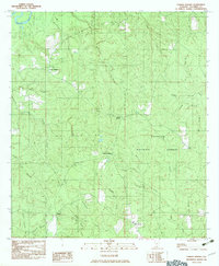 1982 Parker Springs1983 Print · USGSEscambia County, Alabama, is shown in the early eighties as a landscape shaped by the Conecuh National Forest and its winding waterways. Researchers can trace rural settlements like Alaflora and Parker Springs alongside family landmarks like Henley Roberts.
 - 1986 Map of Andalusia
 1986 Andalusia1986 Print · USGSCovington County and the Wiregrass region are shown here in the mid-1980s, centered on the growing hubs of Andalusia and Opp. Genealogists and local historians can trace legacy sites like the Old Pioneer Cem, Straughn Sch, and the rail lines of the Louisville and Nashville RR.2 unique versions available
End of results
Showing maps 1-2 of 2
Top cities near Parker Springs
Frequently asked questions
- What are the different types of historical maps available for Parker Springs?
- What is the oldest map of Parker Springs?
- Where can I purchase historical maps of Parker Springs for my home or office?
- Where can I download high-res historical maps of Parker Springs?
- Are there historical topographic maps available for Parker Springs?
- Is there historical aerial imagery available for Parker Springs?
- Where are historical maps of Parker Springs sourced from?