1960s Maps of Rehobeth, Alabama
Explore 2 historic maps of Rehobeth from the 1960s. These maps offer a rare glimpse into what life looked like during the 1960s — showing old roads, neighborhoods, homes, and landmarks that have changed or disappeared over time.
Whether you're researching your family's past, planning a metal detecting trip, or studying how Rehobeth's landscape evolved across the 1960s, these high-resolution maps are a powerful tool for exploring the history of this region.
- Focus on a specific era: All maps on this page are from the 1960s, giving you a focused view of this time period.
- See what’s changed: Compare century-old streets, trails, and buildings to today's modern landscape using overlays and satellite layers.
- Research with precision: Use these maps for genealogy, historical research, land use analysis, or educational projects.
- View, download, or print: Maps are fully viewable online in high resolution, and can be downloaded or printed for your own records.
Start exploring Rehobeth's history through authentic maps from the 1960s. This is your window into the past.
Rehobeth, AL maps
(2)- 1969 Map of Dothan West, 1971 Print
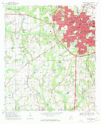 1969 Dothan West1971 Print · USGSDothan and its surrounding crossroads are captured here during a period of significant regional expansion in the late sixties. Researchers can trace historic schools and cemeteries such as Rehobeth High Sch, Carver High Sch, and Mt Zion Cem across the Wiregrass landscape.2 unique versions available
 - 1969 Map of Madrid, 1972 Print
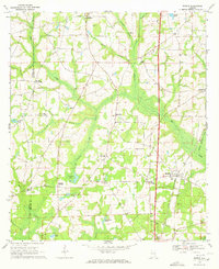 1969 Madrid1972 Print · USGSSoutheastern Alabama's rural landscape comes into focus here during the late sixties as the region’s agricultural and rail patterns remained firmly established. Genealogists can trace family footprints near Madrid and rural church sites like Mt Enon Ch or New Hope Ch.2 unique versions available
End of results
Showing maps 1-2 of 2
Top cities near Rehobeth
- Dothan historical maps
- Headland historical maps
- Daleville historical maps
- Hartford historical maps
- Taylor historical maps
- Ashford historical maps
See more
Top neighborhoods of Rehobeth
Frequently asked questions
- What are the different types of historical maps available for Rehobeth?
- What is the oldest map of Rehobeth?
- Where can I purchase historical maps of Rehobeth for my home or office?
- Where can I download high-res historical maps of Rehobeth?
- Are there historical topographic maps available for Rehobeth?
- Is there historical aerial imagery available for Rehobeth?
- Where are historical maps of Rehobeth sourced from?