1970s Maps of Graysville, Alabama
Explore 4 historic maps of Graysville from the 1970s. These maps offer a rare glimpse into what life looked like during the 1970s — showing old roads, neighborhoods, homes, and landmarks that have changed or disappeared over time.
Whether you're researching your family's past, planning a metal detecting trip, or studying how Graysville's landscape evolved across the 1970s, these high-resolution maps are a powerful tool for exploring the history of this region.
- Focus on a specific era: All maps on this page are from the 1970s, giving you a focused view of this time period.
- See what’s changed: Compare century-old streets, trails, and buildings to today's modern landscape using overlays and satellite layers.
- Research with precision: Use these maps for genealogy, historical research, land use analysis, or educational projects.
- View, download, or print: Maps are fully viewable online in high resolution, and can be downloaded or printed for your own records.
Start exploring Graysville's history through authentic maps from the 1970s. This is your window into the past.
Graysville, AL maps
(4)- 1971 Map of Dora, 1973 Print
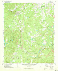 1971 Dora1973 Print · USGSThe river forks of the Alabama coal country come alive in the early seventies, showing a landscape defined by industry and community. Genealogists can trace family roots through Twilley Town, Quintown, and dozens of local landmarks like Morgan Chapel or the Walker Sch.5 unique versions available
 - 1975 Map of Dora, 1977 Print
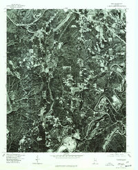 1975 Dora1977 Print · USGSWalker County and the surrounding coal districts are seen here in the mid-seventies through detailed aerial orthophotography. Researchers can trace the development of established towns like Dora, Sumiton, and the hillside layout of West Jefferson.
 - 1975 Map of Adamsville, 1977 Print
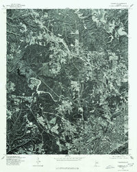 1975 Adamsville1977 Print · USGSBirmingham and its northwestern suburbs are captured in high-detail aerial imagery during the mid-seventies. Local researchers can trace the growth of the city core in Birmingham and examine the early suburban patterns developing around Adamsville.
 - 1975 Map of Brookside, 1977 Print
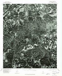 1975 Brookside1977 Print · USGSJefferson County coal country is captured in the mid-seventies, showing the intersection of industrial mining and small-town life. Trace the development of communities like Brookside, Sayre, and the outskirts of Adamsville across the rugged terrain.
End of results
Showing maps 1-4 of 4
Top cities near Graysville
- Birmingham historical maps
- Hoover historical maps
- Vestavia Hills historical maps
- Homewood historical maps
- Bessemer historical maps
- Mountain Brook historical maps
See more
Top neighborhoods of Graysville
- Daisey City Trailer Park historical maps
- Daisey City historical maps
- Graysville Heights historical maps
- Red Wine historical maps
- Sherwood Hills historical maps
- Littleton historical maps
See more
Frequently asked questions
- What are the different types of historical maps available for Graysville?
- What is the oldest map of Graysville?
- Where can I purchase historical maps of Graysville for my home or office?
- Where can I download high-res historical maps of Graysville?
- Are there historical topographic maps available for Graysville?
- Is there historical aerial imagery available for Graysville?
- Where are historical maps of Graysville sourced from?