1980s Maps of Lamar County, Alabama
Explore 8 historic maps of Lamar County from the 1980s. These maps offer a rare glimpse into what life looked like during the 1980s — showing old roads, neighborhoods, homes, and landmarks that have changed or disappeared over time.
Whether you're researching your family's past, planning a metal detecting trip, or studying how Lamar County's landscape evolved across the 1980s, these high-resolution maps are a powerful tool for exploring the history of this region.
- Focus on a specific era: All maps on this page are from the 1980s, giving you a focused view of this time period.
- See what’s changed: Compare century-old streets, trails, and buildings to today's modern landscape using overlays and satellite layers.
- Research with precision: Use these maps for genealogy, historical research, land use analysis, or educational projects.
- View, download, or print: Maps are fully viewable online in high resolution, and can be downloaded or printed for your own records.
Start exploring Lamar County's history through authentic maps from the 1980s. This is your window into the past.
Lamar County, AL maps
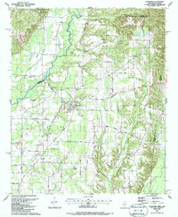
(8)- 1980 Map of Haleyville, 1983 Print
 1980 Haleyville1983 Print · USGSNorthwest Alabama at the start of the eighties shows a landscape of deep forests and new reservoirs as modern infrastructure settled into the hills. Researchers can trace the rail lines of the Southern and Illinois Central Gulf through towns like Haleyville, Moulton, and Natural Bridge.
 - 1982 Map of West Point, 1983 Print
 1982 West Point1983 Print · USGSEastern Mississippi and western Alabama are captured in the early eighties as the river-and-rail economy evolved. Trace family roots and old township lines near West Point, Columbus Air Force Base, and the historic Natchez Trace Parkway.
 - 1984 Map of West Point
 1984 West Point1984 Print · USGSNorth-Central Mississippi in the mid-eighties shows a landscape defined by massive water management projects and dense timberlands. Researchers can trace the legacy of rural settlements like Geeslin Corner or the rail corridors of the Illinois Central Gulf RR near Grenada Lake.3 unique versions available
 - 1984 Map of Tupelo
 1984 Tupelo1984 Print · USGSNorth Mississippi in the 1980s is defined by its massive river basin reservoirs and the growing regional hubs of Tupelo and Oxford. Researchers can trace the legacy of the Pontotoc Ridge, find the University of Mississippi, and map early Interstate corridors near Sardis Lake.3 unique versions available
 - 1984 Map of Jasper, 1985 Print
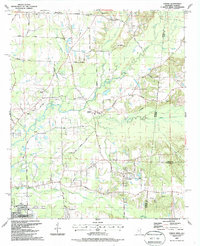
 1984 Jasper1985 Print · USGSIn the mid-1980s, the Walker County coalfields were a complex web of rail lines and river terminals. Researchers can trace the industrial heritage of the Mulberry Fork and locate local landmarks like the Carbon Hill National Fish Hatchery or Saragossa Ch.2 unique versions available
 - 1984 Map of Tupelo, 1985 Print
 1984 Tupelo1985 Print · USGSNortheast Mississippi and the Alabama borderlands are shown in the mid-1980s as timber and river networks shaped the region. Trace local history through the Illinois Central Gulf rail line and sites like the Old Natchez Trace Parkway.
 - 1987 Map of Caledonia
 1987 Caledonia1987 Print · USGSCaledonia sits at the heart of this border region in the 1980s, where the Mississippi and Alabama lines meet. Researchers can trace rural life and ancestry through landmarks like Bethlehem Ch, Unity Cem, and the historic Wolf Road.
 - 1987 Map of Steens
 1987 Steens1987 Print · USGSSteens and the surrounding Lowndes County borderlands are shown in the late eighties as a landscape of rural churches and winding creeks. Genealogists can trace family landmarks like Anderson Grove Sch, New Zion Ch, and Piney Grove Cem along the Southern Railway.
End of results
Showing maps 1-8 of 8
Top cities of Lamar County
- Vernon historical maps
- Sulligent historical maps
- Millport historical maps
- Kennedy historical maps
- Detroit historical maps
- Beaverton historical maps
Frequently asked questions
- What are the different types of historical maps available for Lamar County?
- What is the oldest map of Lamar County?
- Where can I purchase historical maps of Lamar County for my home or office?
- Where can I download high-res historical maps of Lamar County?
- Are there historical topographic maps available for Lamar County?
- Is there historical aerial imagery available for Lamar County?
- Where are historical maps of Lamar County sourced from?