1910s Maps of Mount Olive, Alabama
Explore 2 historic maps of Mount Olive from the 1910s. These maps offer a rare glimpse into what life looked like during the 1910s — showing old roads, neighborhoods, homes, and landmarks that have changed or disappeared over time.
Whether you're researching your family's past, planning a metal detecting trip, or studying how Mount Olive's landscape evolved across the 1910s, these high-resolution maps are a powerful tool for exploring the history of this region.
- Focus on a specific era: All maps on this page are from the 1910s, giving you a focused view of this time period.
- See what’s changed: Compare century-old streets, trails, and buildings to today's modern landscape using overlays and satellite layers.
- Research with precision: Use these maps for genealogy, historical research, land use analysis, or educational projects.
- View, download, or print: Maps are fully viewable online in high resolution, and can be downloaded or printed for your own records.
Start exploring Mount Olive's history through authentic maps from the 1910s. This is your window into the past.
Mount Olive, AL maps
(2)- 1914 Map of Rogersville
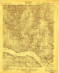 1914 Rogersville1914 Print · USGSBefore the Tennessee River was dammed and widened, this area supported a dense network of river-linked communities. Trace the legacy of early families through landmarks like Lambs Ferry, Mitchell Mill, and the many rural sites like Sweet Gum Church.
 - 1916 Map of Rogersville
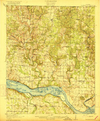 1916 Rogersville1916 Print · USGSLauderdale County was a landscape of river-driven commerce and rural crossroads in the decade before the Tennessee River was transformed. Researchers can trace ancestral locations through dozens of named sites like Lambs Ferry, Hurricane Church, and the Muscle Shoals Canal.2 unique versions available
End of results
Showing maps 1-2 of 2
Top cities near Mount Olive
- Decatur historical maps
- Trinity historical maps
- Rogersville historical maps
- Town Creek historical maps
- Killen historical maps
- Lexington historical maps
See more
Frequently asked questions
- What are the different types of historical maps available for Mount Olive?
- What is the oldest map of Mount Olive?
- Where can I purchase historical maps of Mount Olive for my home or office?
- Where can I download high-res historical maps of Mount Olive?
- Are there historical topographic maps available for Mount Olive?
- Is there historical aerial imagery available for Mount Olive?
- Where are historical maps of Mount Olive sourced from?