1970s Maps of Limestone County, Alabama
Explore 5 historic maps of Limestone County from the 1970s. These maps offer a rare glimpse into what life looked like during the 1970s — showing old roads, neighborhoods, homes, and landmarks that have changed or disappeared over time.
Whether you're researching your family's past, planning a metal detecting trip, or studying how Limestone County's landscape evolved across the 1970s, these high-resolution maps are a powerful tool for exploring the history of this region.
- Focus on a specific era: All maps on this page are from the 1970s, giving you a focused view of this time period.
- See what’s changed: Compare century-old streets, trails, and buildings to today's modern landscape using overlays and satellite layers.
- Research with precision: Use these maps for genealogy, historical research, land use analysis, or educational projects.
- View, download, or print: Maps are fully viewable online in high resolution, and can be downloaded or printed for your own records.
Start exploring Limestone County's history through authentic maps from the 1970s. This is your window into the past.
Limestone County, AL maps
(5)- 1974 Map of Rogersville, 1975 Print
 1974 Rogersville1975 Print · USGSThe Tennessee River and Elk River converge in Lauderdale County during the mid-seventies, a time of established lakeside communities. Researchers can trace family history through dozens of rural burial grounds like Romine Ch Cem and landmarks such as Saltpeter Cave Bluff.
 - 1974 Map of Hillsboro, 1975 Print
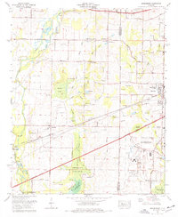
 1974 Hillsboro1975 Print · USGSHillsboro and the banks of the Tennessee River are captured here in the mid-seventies as industry and tradition met. Family historians can locate dozens of burial sites like Shackelford Cem and Graves Cem Church alongside the Southern Railway.
 - 1975 Map of Decatur, 1976 Print
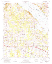
 1975 Decatur1976 Print · USGSDecatur and the Tennessee River valley are shown in the mid-seventies during a period of steady southward expansion. Genealogists and historians can trace family locations at Blackwell Cem or Pisgah Cem, while locating the historic rail lines of the Southern and Louisville and Nashville.3 unique versions available
 - 1975 Map of Greenbrier, 1977 Print
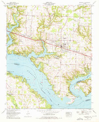
 1975 Greenbrier1977 Print · USGSLimestone and Madison Counties are captured here in the mid-seventies as the area transitioned from a rail-and-gin economy toward modern aviation and urban growth. Genealogists can locate family landmarks like Ragland Cem, Burgreen Gin, and the historic West Madison Sch.3 unique versions available
 - 1976 Map of Jones Crossroads, 1977 Print
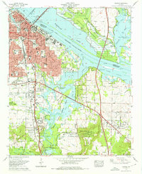
 1976 Jones Crossroads1977 Print · USGSThe Tennessee River valley north of Decatur underwent significant industrial transformation by the mid-seventies. Researchers can trace family history through numerous burial sites like Malone Cem or locate the sprawling Browns Ferry Nuclear Plant.
End of results
Showing maps 1-5 of 5
Top cities of Limestone County
- Athens historical maps
- Ardmore historical maps
- Elkmont historical maps
- Lester historical maps
- Mooresville historical maps
Frequently asked questions
- What are the different types of historical maps available for Limestone County?
- What is the oldest map of Limestone County?
- Where can I purchase historical maps of Limestone County for my home or office?
- Where can I download high-res historical maps of Limestone County?
- Are there historical topographic maps available for Limestone County?
- Is there historical aerial imagery available for Limestone County?
- Where are historical maps of Limestone County sourced from?