Old Maps of Limestone County, Alabama for Academic Research
Study the evolution of Limestone County with 133 high-resolution historic maps. Whether you're teaching, researching, or modeling changes in land use, these maps provide essential visual documentation of urban, environmental, and geographic change.
- Analyze long-term change: Track patterns in development, transportation, and natural features.
- Ideal for environmental or urban studies: Support academic projects with primary historical map data.
- Use in the classroom or lab: Educators and researchers rely on these maps to bring historical context to life.
These maps are a powerful tool for teaching, research, and visualizing how Limestone County has changed over the decades.
Limestone County, AL maps
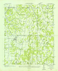
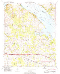
(133)- 1888 Map of Huntsville
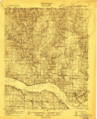
 1888 Huntsville1888 Print · USGSMadison and Limestone counties in the late 1880s showcase a landscape defined by the Tennessee River and major early rail lines. Researchers can trace the layout of Huntsville or locate long-standing communities like Mooresville and Thompsons Mill.
 - 1892 Map of Huntsville
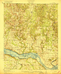
 1892 Huntsville1892 Print · USGSNorth Alabama was a landscape of river ferries and rising rail hubs in the 1890s, caught here just as the region's industry began to modernize. Researchers can locate vanished landmarks like the Monte Sano Hotel and trace old family-named sites from Thompsons Mill to Lemans Ferry.6 unique versions available
 - 1914 Map of Rogersville
 1914 Rogersville1914 Print · USGSBefore the Tennessee River was dammed and widened, this area supported a dense network of river-linked communities. Trace the legacy of early families through landmarks like Lambs Ferry, Mitchell Mill, and the many rural sites like Sweet Gum Church.
 - 1916 Map of Rogersville
 1916 Rogersville1916 Print · USGSLauderdale County was a landscape of river-driven commerce and rural crossroads in the decade before the Tennessee River was transformed. Researchers can trace ancestral locations through dozens of named sites like Lambs Ferry, Hurricane Church, and the Muscle Shoals Canal.2 unique versions available
 - 1935 Map of Athens
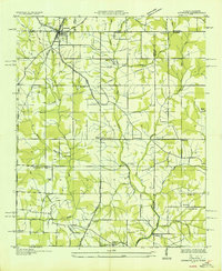
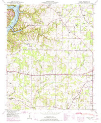
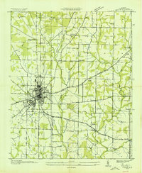 1935 Athens1935 Print · USGSMid-1930s Limestone County comes into focus as an agricultural landscape transitioning into a new era of infrastructure. Family researchers can locate rural anchors like Holt Store, Johnson Cem, and several local schools from Turner Hill Sch to St John Sch.
 - 1936 Map of Capshaw
 1936 Capshaw1936 Print · USGSLimestone and Madison counties are captured here in the mid-1930s as the Tennessee Valley Authority and Alabama Power began modernizing the rural landscape. Researchers can locate numerous vanished country schools like Grimett Sch, family landmarks such as McCully Mill, and the community at Wesley Chapel.
 - 1936 Map of Union Hill
 1936 Union Hill1936 Print · USGSThe Alabama and Tennessee borderlands are captured here in the mid-1930s as modern infrastructure arrived in a landscape of small family farms. Researchers can locate long-standing landmarks like Ridgeways Mill, Hester Cem, and the rural community of Good Springs.
 - 1936 Map of Decatur
 1936 Decatur1936 Print · USGSDecatur and the Tennessee River valley are captured here during the transformative years of the Tennessee Valley Authority. Trace early neighborhoods and rural landmarks like Blackwell Cem, Priceville Sch, and the Brick Kilns.
 - 1936 Map of Thorntontown
 1936 Thorntontown1936 Print · USGSLauderdale County was undergoing a massive transformation in the mid-1930s as the Tennessee Valley Authority flooded the river basin. Researchers can trace the submerged geography of Former Islands or locate family sites like Fuqua Cem and Haraway Sch.
 - 1936 Map of Stewart Cross Roads
 1936 Stewart Cross Roads1936 Print · USGSThe Tennessee River valley underwent a massive transformation in the mid-1930s as the new reservoir flooded the lowlands. You can trace submerged riverbanks and find upland landmarks like Stewart Cross Roads, Beulah Land, and St Luke Sch.
 - 1936 Map of Elkmont
 1936 Elkmont1936 Print · USGSThe Tennessee-Alabama borderlands come into focus in the mid-1930s, showing a landscape defined by the Louisville and Nashville rail line and rural industry. Genealogists can locate family landmarks like Hays Mill, Holland Gin, and old burial grounds including New Garden Cem.
 - 1936 Map of Ripley
 1936 Ripley1936 Print · USGSLimestone County is captured here in the mid-1930s as the new Wheeler Reservoir began reshaping the local landscape. Genealogists can locate family-named sites like Myers Cem and community centers like Peeks Store or Yarbrough Chapel.
 - 1936 Map of Ardmore
 1936 Ardmore1936 Print · USGSThe Alabama-Tennessee borderlands appear here in the mid-1930s, showing the early growth of ARDMORE along the LOUISVILLE AND NASHVILLE railroad. Genealogists can trace family landmarks like Hatchett Cem and rural school sites such as Wooley Springs Sch.
 - 1936 Map of Hillsboro
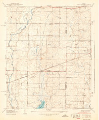
 1936 Hillsboro1936 Print · USGSHillsboro and the Tennessee River banks are captured here during the transformative mid-1930s as the new reservoir began to fill. Local historians can locate early schools and churches such as Ebenezer Sch, Canaan Ch, and the riverside Milton Bluff.
 - 1936 Map of Mason Ridge
 1936 Mason Ridge1936 Print · USGSThe Tennessee River valley underwent a total transformation in the mid-1930s as the new Wheeler Reservoir filled. Researchers can trace displaced landmarks like Cane Landing or visit upland sites like Needmore Sch and Kolb Cem.
 - 1936 Map of Tanner
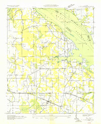
 1936 Tanner1936 Print · USGSLimestone County is captured during the transformative years of the Tennessee Valley Authority project. Researchers can trace family sites and rural landmarks like Mooresville, Taylor Pride Cem, and the Alabama State Farm near the rising waters of Wheeler Reservoir.
 - 1936 Map of Cairo
 1936 Cairo1936 Print · USGSLimestone County and the newly formed Wheeler Reservoir are captured here during a pivotal era of regional change. Researchers can trace the submerged Former Tennessee River and locate community sites like Coxey and Temperance Oak Sch.
 - 1936 Map of Greenbrier
 1936 Greenbrier1936 Print · USGSAlabama's Tennessee Valley was undergoing a massive transformation in the mid-1930s as the river was harnessed for power. Genealogists can locate family-named settlements like Peete Corners, small rural schools like Betz Sch, and old spiritual centers like Fletcher Chapel.
 - 1936 Map of Salem
 1936 Salem1936 Print · USGSNorthern Alabama in the mid-thirties shows a landscape being reshaped by the rising waters of Wheeler Reservoir. Genealogists can trace early homesteads and family sites like Conniegun Cem and Walnut Grove Ch.
 - 1938 Map of Tanner
 1938 Tanner1938 Print · USGSLimestone County in the late thirties shows a landscape transformed by the new Wheeler Reservoir and its rising waters. Genealogists can trace family holdings and community hubs like Anderson Plantation, Taylor Pride Cem, and Mooresville.
 - 1938 Map of Greenbrier
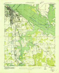
 1938 Greenbrier1938 Print · USGSLimestone and Madison Counties are shown in the late 1930s as a landscape of rural schoolhouses and family cemeteries. Genealogists can trace local heritage through sites like Ragland Cem, Mt Pleasant Sch, and the crossroads at Burgreen Corner.3 unique versions available
 - 1948 Map of Hillsboro, 1969 Print
 1948 Hillsboro1969 Print · USGSLawrence County and the Tennessee River shoreline are captured here in the late 1940s as the regional landscape adjusted to the presence of Wheeler Lake. Genealogists can trace family roots through numerous local landmarks, including Pointer Quarters, Bethel Ch, and Hillsboro Cem.
 - 1948 Map of Union Hill, 1973 Print
 1948 Union Hill1973 Print · USGSThe Alabama-Tennessee borderlands appear here in the mid-twentieth century as a landscape of small farming hamlets and creek-side industry. Researchers can locate family landmarks like Ridgway Mill, Hester Chapel, and the McCraw Cem along the banks of Sugar Creek.
 - 1948 Map of Ripley, 1974 Print
 1948 Ripley1974 Print · USGSSettled hills and river bottoms in Limestone County appear here in the late forties as the Tennessee Valley Authority managed the local landscape. Researchers can trace rural family roots at Riddle Chapel, Turner Chapel School, and the Persimmon Grove Cem.2 unique versions available
 - 1948 Map of Salem, 1974 Print
 1948 Salem1974 Print · USGSThe Alabama-Tennessee borderlands appear here in the late 1940s, showing a river-valley landscape being reshaped by the Wheeler Reservoir. Researchers can trace old family footprints at Leggtown, Gourdsville, and the ELK RIVER FISH HATCHERY, alongside numerous rural burial sites like Nelson Cem.
Showing maps 1-25 of 133
Top cities of Limestone County
- Athens historical maps
- Ardmore historical maps
- Elkmont historical maps
- Lester historical maps
- Mooresville historical maps
Frequently asked questions
- What are the different types of historical maps available for Limestone County?
- What is the oldest map of Limestone County?
- Where can I purchase historical maps of Limestone County for my home or office?
- Where can I download high-res historical maps of Limestone County?
- Are there historical topographic maps available for Limestone County?
- Is there historical aerial imagery available for Limestone County?
- Where are historical maps of Limestone County sourced from?