1950s Maps of Athens, Alabama
Explore 6 historic maps of Athens from the 1950s. These maps offer a rare glimpse into what life looked like during the 1950s — showing old roads, neighborhoods, homes, and landmarks that have changed or disappeared over time.
Whether you're researching your family's past, planning a metal detecting trip, or studying how Athens's landscape evolved across the 1950s, these high-resolution maps are a powerful tool for exploring the history of this region.
- Focus on a specific era: All maps on this page are from the 1950s, giving you a focused view of this time period.
- See what’s changed: Compare century-old streets, trails, and buildings to today's modern landscape using overlays and satellite layers.
- Research with precision: Use these maps for genealogy, historical research, land use analysis, or educational projects.
- View, download, or print: Maps are fully viewable online in high resolution, and can be downloaded or printed for your own records.
Start exploring Athens's history through authentic maps from the 1950s. This is your window into the past.
Athens, AL maps
(6)- 1950 Map of Jones Crossroads
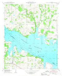 1950 Jones Crossroads1950 Print · USGSLimestone and Morgan counties meet along the wide waters of the Tennessee River in the post-war era. Genealogists and local historians can trace family plots at Neville Cem or locate community centers like Jones Crossroads and the Pine Ridge School.3 unique versions available
 - 1951 Map of Ripley
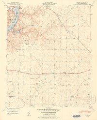 1951 Ripley1951 Print · USGSLimestone County in the early fifties shows a rural landscape shaped by the Elk River and new reservoir shorelines. Researchers can trace family history through numerous small settlements like Shanghai and family burial grounds such as McKinney Cem and Farrow Cem.2 unique versions available
 - 1956 Map of Gadsden, 1966 Print
 1956 Gadsden1966 Print · USGSNorth Alabama in the mid-1950s shows a region transformed by river engineering and federal industry. Genealogists and local historians can trace the development of the Tennessee Valley through the growth of Huntsville, the sprawling Redstone Arsenal, and the expansive Guntersville Lake.3 unique versions available
 - 1958 Map of Gadsden
 1958 Gadsden1958 Print · USGSNorth Alabama comes alive in the late 1950s as the Tennessee Valley Authority’s massive river projects and the rise of the space industry reshaped the landscape. Researchers can trace the mid-century footprints of Huntsville, Redstone Arsenal, and the riverside rail networks of the Southern railroad.
 - 1958 Map of Capshaw, 1959 Print
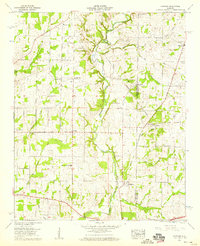 1958 Capshaw1959 Print · USGSThe rural border of Limestone and Madison counties is captured here in the late fifties as family farms and small crossroad communities thrived. Researchers can trace the Old Railroad Bed and locate historic sites like Pilgrim Home Church and Nick Davis Cem.3 unique versions available
 - 1958 Map of Athens, 1959 Print
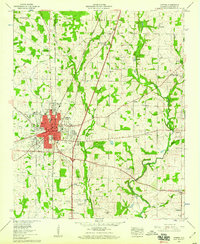 1958 Athens1959 Print · USGSMid-century Athens and its Limestone County surrounds are captured here during a period of steady growth along the major highways and rail lines. Researchers can trace family sites at Fielding Cem, explore the historic campus of Athens College, and locate rural outposts like Wigginsville and Sardis Springs.
End of results
Showing maps 1-6 of 6
Top cities near Athens
- Huntsville historical maps
- Decatur historical maps
- Madison historical maps
- Harvest historical maps
- Priceville historical maps
- Triana historical maps
See more
Top neighborhoods of Athens
- Wigginsville historical maps
- Batts Heights historical maps
- Canebrake historical maps
- Lake Ida Heights historical maps
- Breeding Industrial Park historical maps
- Elm Industrial Park historical maps
Frequently asked questions
- What are the different types of historical maps available for Athens?
- What is the oldest map of Athens?
- Where can I purchase historical maps of Athens for my home or office?
- Where can I download high-res historical maps of Athens?
- Are there historical topographic maps available for Athens?
- Is there historical aerial imagery available for Athens?
- Where are historical maps of Athens sourced from?