1930s Maps of Athens, Alabama
Explore 6 historic maps of Athens from the 1930s. These maps offer a rare glimpse into what life looked like during the 1930s — showing old roads, neighborhoods, homes, and landmarks that have changed or disappeared over time.
Whether you're researching your family's past, planning a metal detecting trip, or studying how Athens's landscape evolved across the 1930s, these high-resolution maps are a powerful tool for exploring the history of this region.
- Focus on a specific era: All maps on this page are from the 1930s, giving you a focused view of this time period.
- See what’s changed: Compare century-old streets, trails, and buildings to today's modern landscape using overlays and satellite layers.
- Research with precision: Use these maps for genealogy, historical research, land use analysis, or educational projects.
- View, download, or print: Maps are fully viewable online in high resolution, and can be downloaded or printed for your own records.
Start exploring Athens's history through authentic maps from the 1930s. This is your window into the past.
Athens, AL maps
(6)- 1935 Map of Athens
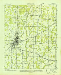 1935 Athens1935 Print · USGSMid-1930s Limestone County comes into focus as an agricultural landscape transitioning into a new era of infrastructure. Family researchers can locate rural anchors like Holt Store, Johnson Cem, and several local schools from Turner Hill Sch to St John Sch.
 - 1936 Map of Capshaw
 1936 Capshaw1936 Print · USGSLimestone and Madison counties are captured here in the mid-1930s as the Tennessee Valley Authority and Alabama Power began modernizing the rural landscape. Researchers can locate numerous vanished country schools like Grimett Sch, family landmarks such as McCully Mill, and the community at Wesley Chapel.
 - 1936 Map of Stewart Cross Roads
 1936 Stewart Cross Roads1936 Print · USGSThe Tennessee River valley underwent a massive transformation in the mid-1930s as the new reservoir flooded the lowlands. You can trace submerged riverbanks and find upland landmarks like Stewart Cross Roads, Beulah Land, and St Luke Sch.
 - 1936 Map of Ripley
 1936 Ripley1936 Print · USGSLimestone County is captured here in the mid-1930s as the new Wheeler Reservoir began reshaping the local landscape. Genealogists can locate family-named sites like Myers Cem and community centers like Peeks Store or Yarbrough Chapel.
 - 1936 Map of Tanner
 1936 Tanner1936 Print · USGSLimestone County is captured during the transformative years of the Tennessee Valley Authority project. Researchers can trace family sites and rural landmarks like Mooresville, Taylor Pride Cem, and the Alabama State Farm near the rising waters of Wheeler Reservoir.
 - 1938 Map of Tanner
 1938 Tanner1938 Print · USGSLimestone County in the late thirties shows a landscape transformed by the new Wheeler Reservoir and its rising waters. Genealogists can trace family holdings and community hubs like Anderson Plantation, Taylor Pride Cem, and Mooresville.
End of results
Showing maps 1-6 of 6
Top cities near Athens
- Huntsville historical maps
- Decatur historical maps
- Madison historical maps
- Harvest historical maps
- Priceville historical maps
- Triana historical maps
See more
Top neighborhoods of Athens
- Wigginsville historical maps
- Batts Heights historical maps
- Canebrake historical maps
- Lake Ida Heights historical maps
- Breeding Industrial Park historical maps
- Elm Industrial Park historical maps
Frequently asked questions
- What are the different types of historical maps available for Athens?
- What is the oldest map of Athens?
- Where can I purchase historical maps of Athens for my home or office?
- Where can I download high-res historical maps of Athens?
- Are there historical topographic maps available for Athens?
- Is there historical aerial imagery available for Athens?
- Where are historical maps of Athens sourced from?