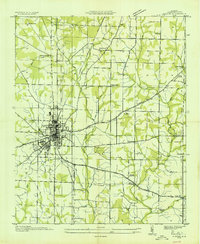
1935 Map of Athens
USGS Topo · Published 1935About this map
Athens serves as the central hub for Limestone County in this mid-1930s survey, showing a concentrated grid of streets and buildings surrounded by a network of rural schoolhouses and family-named landmarks. The Louisville and Nashville Line cuts vertically through the landscape, alongside a significant corridor for the Alabama Power Company Transmission Line, reflecting the early integration of industrial infrastructure in this agricultural region. Outside the town limits, the landscape is defined by its small community centers like Holt Store and Thomas Store. The Tennessee Valley Authority's presence is noted through the Tennessee Valley Authority Transmission Line, while local life is anchored by numerous rural schools and churches such as Alabama Fork Sch and Sardis Spring Ch. A notable landmark of the New Deal era is the CCC Camp No 6, located just west of the city center, marking the labor and conservation efforts of the period.
Find a feature on this map
38 named features on this map. Tap any name to fly to it.
Don’t see what you’re looking for? This feature index may not catch every label — zoom into the map to look around manually.
Map Details
Editions of this 1935 Athens Map
This is the sole edition of this map. No revisions or reprints were ever made.
Other maps of this area

1888 · Huntsville
USGS Topo · 1:125,000

1892 · Huntsville
USGS Topo · 1:125,000

1936 · Capshaw
USGS Topo · 1:24,000

1936 · Stewart Cross Roads
USGS Topo · 1:24,000
1936 · Elkmont
USGS Topo · 1:24,000

1936 · Ripley
USGS Topo · 1:24,000
1936 · Ardmore
USGS Topo · 1:24,000

1936 · Tanner
USGS Topo · 1:24,000

1936 · Greenbrier
USGS Topo · 1:24,000

1936 · Salem
USGS Topo · 1:24,000