
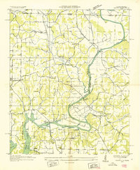
1936 Map of Elkmont
USGS Topo · Published 1936About this map
Elkmont serves as the central hub of this 1936 survey, which documents the borderlands of north-central Alabama as they appeared during the Tennessee Valley Authority's early development. The landscape is defined by the Louisville and Nashville railroad, which threads through the territory across landmarks like Holt Trestle. The rural economy of the mid-1930s is visible in the distribution of industrial sites like Hays Mill, Woodfin Mill, and Holland Gin, indicating a region deeply tied to water-driven milling and cotton processing. Cultural life is anchored by numerous country churches and schools, including Antioch Ch and Adams Sch, while the Tennessee-Alabama state line and the boundary between Giles and Limestone counties divide the northern reaches. This field examination provides a clear look at the network of hollows, such as Redus Hollow, and creeks like Chickasaw Creek that dictated the placement of small communities like Pettusville and Veto.
Find a feature on this map
48 named features on this map. Tap any name to fly to it.
Don’t see what you’re looking for? This feature index may not catch every label — zoom into the map to look around manually.
Map Details
Editions of this 1936 Elkmont Map
This is the sole edition of this map. No revisions or reprints were ever made.
Other maps of this area

1888 · Huntsville
USGS Topo · 1:125,000

1892 · Huntsville
USGS Topo · 1:125,000

1935 · Athens
USGS Topo · 1:24,000

1936 · Capshaw
USGS Topo · 1:24,000

1936 · Aspen Hill
USGS Topo · 1:24,000

1936 · Ripley
USGS Topo · 1:24,000

1936 · Ardmore
USGS Topo · 1:24,000

1936 · Elkton
USGS Topo · 1:24,000

1936 · Dellrose
USGS Topo · 1:24,000
1936 · Salem
USGS Topo · 1:24,000