
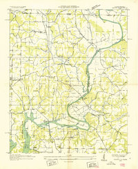
1936 Map of Elkton
USGS Topo · Published 1936About this map
Elkton and Prospect anchor this mid-1930s landscape along the winding course of the Elk River and Richland Creek. This era reveals a river-driven rural economy, where the Vinta Mill and Murrell Mill stand as key landmarks along the waterways. The presence of the Electric Power Company Transmission Line and various Tva Transmission Line routes across the terrain indicates the significant infrastructure changes brought by the Tennessee Valley Authority during this period. Local life is centered around family-named schools and churches like the Conway Sch and Poplar Hill Ch, while the Louisville And Nashville railroad provides a vital connection to the broader region. Small community hubs like Rolins Store and industrial sites such as the Lime Kiln further illustrate the self-sustaining character of this Giles County landscape before modern development.
Find a feature on this map
82 named features on this map. Tap any name to fly to it.
Don’t see what you’re looking for? This feature index may not catch every label — zoom into the map to look around manually.
Map Details
Editions of this 1936 Elkton Map
This is the sole edition of this map. No revisions or reprints were ever made.
Other maps of this area

1888 · Huntsville
USGS Topo · 1:125,000

1892 · Huntsville
USGS Topo · 1:125,000

1936 · Aspen Hill
USGS Topo · 1:24,000

1936 · Elkmont
USGS Topo · 1:24,000

1936 · Ardmore
USGS Topo · 1:24,000

1936 · Pulaski
USGS Topo · 1:24,000

1936 · Tarpley
USGS Topo · 1:24,000

1936 · Frankewing
USGS Topo · 1:24,000

1936 · Dellrose
USGS Topo · 1:24,000
1936 · Salem
USGS Topo · 1:24,000