1930s Maps of Hillmont, Huntsville
Explore 1 historic maps of Hillmont from the 1930s. These maps offer a rare glimpse into what life looked like during the 1930s — showing old roads, neighborhoods, homes, and landmarks that have changed or disappeared over time.
Whether you're researching your family's past, planning a metal detecting trip, or studying how Hillmont's landscape evolved across the 1930s, these high-resolution maps are a powerful tool for exploring the history of this region.
- Focus on a specific era: All maps on this page are from the 1930s, giving you a focused view of this time period.
- See what’s changed: Compare century-old streets, trails, and buildings to today's modern landscape using overlays and satellite layers.
- Research with precision: Use these maps for genealogy, historical research, land use analysis, or educational projects.
- View, download, or print: Maps are fully viewable online in high resolution, and can be downloaded or printed for your own records.
Start exploring Hillmont's history through authentic maps from the 1930s. This is your window into the past.
Hillmont, Huntsville maps
(1)- 1936 Map of Huntsville
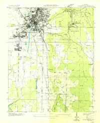 1936 Huntsville1936 Print · USGSHuntsville was a bustling railway and textile hub in the mid-thirties, just before the arrival of the space industry. Genealogists and historians can trace the footprint of early mill villages like Merrimac or locate family plots at Maple Hill Cem and Sivley Cem.
End of results
Showing maps 1-1 of 1
Top cities near Hillmont
- Huntsville historical maps
- Madison historical maps
- Meridianville historical maps
- Moores Mill historical maps
- Harvest historical maps
- Hazel Green historical maps
See more
Frequently asked questions
- What are the different types of historical maps available for Hillmont?
- What is the oldest map of Hillmont?
- Where can I purchase historical maps of Hillmont for my home or office?
- Where can I download high-res historical maps of Hillmont?
- Are there historical topographic maps available for Hillmont?
- Is there historical aerial imagery available for Hillmont?
- Where are historical maps of Hillmont sourced from?