1940s Maps of Sulphur Springs, Alabama
Explore 1 historic maps of Sulphur Springs from the 1940s. These maps offer a rare glimpse into what life looked like during the 1940s — showing old roads, neighborhoods, homes, and landmarks that have changed or disappeared over time.
Whether you're researching your family's past, planning a metal detecting trip, or studying how Sulphur Springs's landscape evolved across the 1940s, these high-resolution maps are a powerful tool for exploring the history of this region.
- Focus on a specific era: All maps on this page are from the 1940s, giving you a focused view of this time period.
- See what’s changed: Compare century-old streets, trails, and buildings to today's modern landscape using overlays and satellite layers.
- Research with precision: Use these maps for genealogy, historical research, land use analysis, or educational projects.
- View, download, or print: Maps are fully viewable online in high resolution, and can be downloaded or printed for your own records.
Start exploring Sulphur Springs's history through authentic maps from the 1940s. This is your window into the past.
Sulphur Springs, AL maps
(1)- 1948 Map of Fisk, 1971 Print
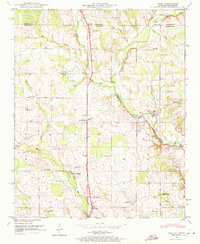 1948 Fisk1971 Print · USGSMadison County, Alabama, and Lincoln County, Tennessee, meet at this mid-century rural crossroads where the Flint River valley supported a landscape of mills and country churches. Researchers can trace family sites like Stegers Store, Farmers Capitol School, and Townsend Cem along the old short route.2 unique versions available
End of results
Showing maps 1-1 of 1
Top cities near Sulphur Springs
- Huntsville historical maps
- Madison historical maps
- Meridianville historical maps
- Fayetteville historical maps
- Moores Mill historical maps
- Hazel Green historical maps
See more
Frequently asked questions
- What are the different types of historical maps available for Sulphur Springs?
- What is the oldest map of Sulphur Springs?
- Where can I purchase historical maps of Sulphur Springs for my home or office?
- Where can I download high-res historical maps of Sulphur Springs?
- Are there historical topographic maps available for Sulphur Springs?
- Is there historical aerial imagery available for Sulphur Springs?
- Where are historical maps of Sulphur Springs sourced from?