1970s Maps of Demopolis, Alabama
Explore 2 historic maps of Demopolis from the 1970s. These maps offer a rare glimpse into what life looked like during the 1970s — showing old roads, neighborhoods, homes, and landmarks that have changed or disappeared over time.
Whether you're researching your family's past, planning a metal detecting trip, or studying how Demopolis's landscape evolved across the 1970s, these high-resolution maps are a powerful tool for exploring the history of this region.
- Focus on a specific era: All maps on this page are from the 1970s, giving you a focused view of this time period.
- See what’s changed: Compare century-old streets, trails, and buildings to today's modern landscape using overlays and satellite layers.
- Research with precision: Use these maps for genealogy, historical research, land use analysis, or educational projects.
- View, download, or print: Maps are fully viewable online in high resolution, and can be downloaded or printed for your own records.
Start exploring Demopolis's history through authentic maps from the 1970s. This is your window into the past.
Demopolis, AL maps
(2)- 1970 Map of Jefferson, 1973 Print
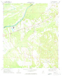 1970 Jefferson1973 Print · USGSThe Tombigbee River valley in Marengo County comes into focus during the early seventies, detailing the rural communities of Jefferson and Moscow. Researchers can trace old rail lines like the Southern and find landmarks such as Essex Sch and Salt Well.3 unique versions available
 - 1970 Map of Old Spring Hill, 1973 Print
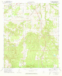 1970 Old Spring Hill1973 Print · USGSMarengo County's rural character and church-centered communities are preserved here in the early seventies. Genealogists and historians can trace the locations of numerous landmarks like Old Spring Hill, Old Mt Canaan Ch, and Lake Miriam.2 unique versions available
End of results
Showing maps 1-2 of 2
Top cities near Demopolis
- Greensboro historical maps
- Linden historical maps
- Forkland historical maps
- Thomaston historical maps
- Providence historical maps
- Dayton historical maps
Top neighborhoods of Demopolis
- Shortleaf historical maps
- Baptist Hill historical maps
- Knoxwood historical maps
- Spocari historical maps
- Rockcut historical maps
Frequently asked questions
- What are the different types of historical maps available for Demopolis?
- What is the oldest map of Demopolis?
- Where can I purchase historical maps of Demopolis for my home or office?
- Where can I download high-res historical maps of Demopolis?
- Are there historical topographic maps available for Demopolis?
- Is there historical aerial imagery available for Demopolis?
- Where are historical maps of Demopolis sourced from?