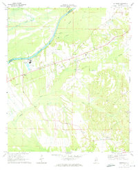
1970 Map of Jefferson
USGS Topo · Published 1973About this map
The Tombigbee River forms a significant bend through this 1970 landscape, marking the boundary between Sumter and Marengo counties. Along the eastern banks, the map captures a rural network of small communities and infrastructure, including the settlement of Moscow and the airfield at Boykin Field. The presence of Salt Well and numerous small drainages like Lost Creek and Cypress Creek indicate the low-lying, hydrologically active nature of the river valley.
Find a feature on this map
22 named features on this map. Tap any name to fly to it.
Don’t see what you’re looking for? This feature index may not catch every label — zoom into the map to look around manually.
Map Details
Editions of this 1970 Jefferson Map
3 editions found
Other maps of this area

1929 · Epes
USGS Topo · 1:48,000

1932 · Epes
USGS Topo · 1:62,500

1946 · Demopolis
USGS Topo · 1:24,000

1947 · Demopolis
USGS Topo · 1:24,000

1948 · Mc Dowell
USGS Topo · 1:24,000

1949 · Mc Dowell
USGS Topo · 1:24,000

1953 · Montgomery
USGS Topo · 1:250,000

1953 · Meridian
USGS Topo · 1:250,000

1956 · Montgomery
USGS Topo · 1:250,000

1957 · Meridian
USGS Topo · 1:250,000