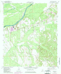
1970 Map of Jefferson
USGS Topo · Published 1987About this map
The Tombigbee River-Black Warrior-Tombigbee Waterway defines the western edge of this landscape, separating Marengo and Sumter counties. Along its banks, traditional river access points like Simmons Landing and Paces Landing sit near the modern Demopolis Municipal Airport, illustrating the shift from river-based transport to regional aviation. Further inland, the settlement of Jefferson anchors the southern portion of the sheet, while the rural communities of Moscow and surrounding areas are marked by several local landmarks. Genealogy and local history researchers will find the locations of Bethel Ch, Friendship Ch, and Mt Zion Ch alongside the Essex Sch. The rail infrastructure is well-represented by the crossing of the Southern and Burlington Northern lines, which cut through the central terrain near Salt Well and the industrial Filtration Plant.
Find a feature on this map
27 named features on this map. Tap any name to fly to it.
Don’t see what you’re looking for? This feature index may not catch every label — zoom into the map to look around manually.
Map Details
Editions of this 1970 Jefferson Map
3 editions found
Other maps of this area

1929 · Epes
USGS Topo · 1:48,000

1932 · Epes
USGS Topo · 1:62,500

1946 · Demopolis
USGS Topo · 1:24,000

1947 · Demopolis
USGS Topo · 1:24,000

1948 · Mc Dowell
USGS Topo · 1:24,000

1949 · Mc Dowell
USGS Topo · 1:24,000

1953 · Montgomery
USGS Topo · 1:250,000

1953 · Meridian
USGS Topo · 1:250,000

1956 · Montgomery
USGS Topo · 1:250,000

1957 · Meridian
USGS Topo · 1:250,000