Old Maps of Marion County, Alabama for Genealogy
Trace your family roots with 131 historic maps of Marion County. These high-res maps reveal old neighborhoods, homesites, landmarks, and streets — helping you uncover where your ancestors lived and how the area evolved over time.
- Explore historic neighborhoods: Identify where your relatives may have lived in the 1800s or 1900s.
- Compare maps over time: Trace the changes in streets, buildings, and landmarks for multi-generational research.
- Perfect for genealogy & ancestry research: Used by family historians and researchers to map out lineage and migration.
These maps are an incredible resource for exploring your personal connection to Marion County's past.
Marion County, AL maps
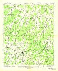
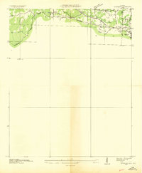
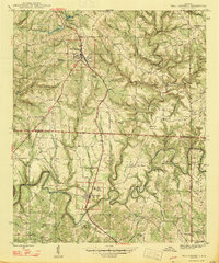
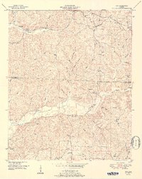
(131)- 1936 Map of Hodges
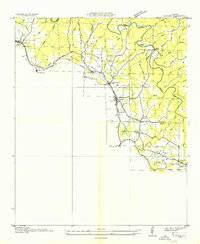 1936 Hodges1936 Print · USGSNorthwest Alabama at the height of the New Deal era reveals a rural landscape shaped by winding creeks and early industrial corridors. Genealogists can locate family landmarks like Mc Curley Cem, Old Lion Ch, and the historic Alabama Military Road.
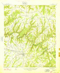
 - 1936 Map of Phil Campbell
 1936 Phil Campbell1936 Print · USGSNorthwest Alabama at the height of the mid-thirties shows a landscape of ridge-top settlements and creek-side industry. Genealogists can trace family roots through numerous rural landmarks like Morris Hill Ch, Phillips Sch, and the Lowler Mines.
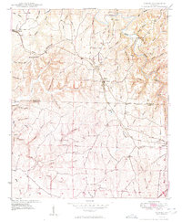
 - 1936 Map of South Of Hackleburg
 1936 South Of Hackleburg1936 Print · USGSMarion County, Alabama, is captured in this mid-1930s field examination focused on the drainage of the Tennessee River system. Researchers can trace the hydrography of Brush Creek and the topography of the Basin and Divide.
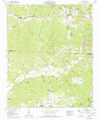
 - 1936 Map of Hackleburg
 1936 Hackleburg1936 Print · USGSMarion and Franklin counties come into focus during the mid-thirties as the Tennessee Valley Authority began modernizing the rural landscape. Trace local heritage through landmarks like State Convict Camp D, the Jackson Military Road, and numerous family cemeteries including Grissom Cem.
 - 1936 Map of Goddard
 1936 Goddard1936 Print · USGSNorthern Alabama's ridgeline terrain is documented in the mid-1930s, showing the intersection of heavy rail and forest boundaries. Genealogists can locate Union Grove Ch and Goddard near the Southern rail line and Black Warrior National Forest.
 - 1936 Map of Vina
 1936 Vina1936 Print · USGSThe area surrounding Vina in the mid-1930s is captured here during a period of infrastructure growth and rural transition. Researchers can locate family landmarks like Jones Cem and trace the path of the Illinois Central railroad.
 - 1946 Map of Hackleburg, 1960 Print
 1946 Hackleburg1960 Print · USGSHackleburg and the surrounding Marion County countryside are captured here in the mid-1940s, centered on the Illinois Central Railroad corridor. Researchers can locate early family landmarks like Lawler Cem or trace the old Military Road as it crosses Bear Creek.3 unique versions available
 - 1946 Map of Phil Campbell, 1967 Print
 1946 Phil Campbell1967 Print · USGSNorthwestern Alabama in the mid-1940s reveals a landscape defined by the SOUTHERN rail line and deep mining roots. Trace the locations of early rural schools and churches like Phillips High Sch and Shady Grove Ch, or locate old mines and the Donaldson Mill.3 unique versions available
 - 1947 Map of Phil Campbell
 1947 Phil Campbell1947 Print · USGSPhil Campbell and Bear Creek anchor this post-war survey of the Alabama hill country at a time when the Southern railroad still fueled local industry. Researchers can trace rural life through numerous sites like Phillips High Sch, Dime, and the Wilson Mine (Aband).2 unique versions available
 - 1948 Map of Hackleburg
 1948 Hackleburg1948 Print · USGSHackleburg and the surrounding rural communities of Northwest Alabama are captured here shortly after the war, centered on the Illinois Central line. You can trace early transit routes along the Military Road and locate family landmarks like Lawler Cem and Gravel Hill School.2 unique versions available
 - 1949 Map of Hodges
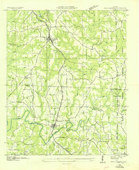
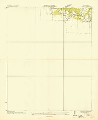
 1949 Hodges1949 Print · USGSNorthwest Alabama at the end of the 1940s reveals a network of small settlements and family landmarks centered on the Illinois Central railroad. Genealogists can trace local roots through sites like Holly Spring Ch, McCurley Cem, and the village of Hodges.2 unique versions available
 - 1950 Map of Vina, 1977 Print
 1950 Vina1977 Print · USGSThe Alabama-Mississippi borderlands come to life in this mid-century survey of the upland country near Vina. Genealogists and historians can trace isolated landmarks like Good Spring Church, the Newburg Cem, and the path of the Illinois Central railroad.
 - 1951 Map of Vina
 1951 Vina1951 Print · USGSNorthwest Alabama at mid-century centers on the corridor between Vina and Shottsville as the rural landscape evolves. Researchers can trace family-named landmarks like Buzzard Bluff, several country schools, and old burial sites such as Brazel Cem and Nichols Cem.2 unique versions available
 - 1953 Map of Birmingham, 1964 Print
 1953 Birmingham1964 Print · USGSCentral Alabama at mid-century shows a landscape defined by industrial expansion and the iron-rich ridges surrounding Birmingham. Researchers can trace the extensive rail networks of the L & N RR or locate historic federal sites like the Anniston Ordnance Depot.4 unique versions available
 - 1956 Map of Birmingham
 1956 Birmingham1956 Print · USGSCentral Alabama in the mid-fifties exhibits a landscape of growing cities and deep-rooted industrial corridors. Genealogists and historians can trace the development of suburban Mountain Brook or locate regional hubs like Sylacauga and Jasper.
 - 1956 Map of Gadsden, 1966 Print
 1956 Gadsden1966 Print · USGSNorth Alabama in the mid-1950s shows a region transformed by river engineering and federal industry. Genealogists and local historians can trace the development of the Tennessee Valley through the growth of Huntsville, the sprawling Redstone Arsenal, and the expansive Guntersville Lake.3 unique versions available
 - 1956 Map of Tupelo, 1967 Print
 1956 Tupelo1967 Print · USGSNortheast Mississippi and parts of Tennessee and Alabama are shown here during the mid-fifties, a time of major reservoir construction and forestry management. Researchers can trace the St Louis-San Francisco RR through Tupelo or locate historic sites like Tishomingo State Park and the University.2 unique versions available
 - 1957 Map of Birmingham
 1957 Birmingham1957 Print · USGSNorth-Central Alabama in the mid-fifties is an industrial powerhouse centered on the steel valleys and sprawling iron ridges. Genealogists and historians can trace the rail-linked growth of Birmingham and Tuscaloosa, or locate rural landmarks like Talladega College and the Anniston Ordnance Depot.
 - 1958 Map of Tupelo
 1958 Tupelo1958 Print · USGSNortheast Mississippi and neighboring Alabama and Tennessee appear here during the late fifties as a region defined by new reservoirs and historic rail lines. Genealogists can trace family locations near Sardis Lake, Woodall Mountain, and the St Louis-San Francisco Ry.
 - 1958 Map of Gadsden
 1958 Gadsden1958 Print · USGSNorth Alabama comes alive in the late 1950s as the Tennessee Valley Authority’s massive river projects and the rise of the space industry reshaped the landscape. Researchers can trace the mid-century footprints of Huntsville, Redstone Arsenal, and the riverside rail networks of the Southern railroad.
 - 1958 Map of Haleyville West, 1960 Print
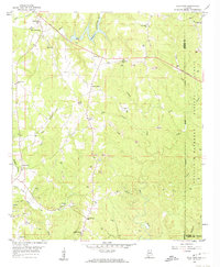
 1958 Haleyville West1960 Print · USGSMarion County in the late fifties remains a landscape of remote hollows and high ridges near the William B Bankhead National Forest. Genealogists and historians can trace family locations through sites like Old Ireland Cem, Goddard, and the Craft Sch.3 unique versions available
 - 1958 Map of Gold Mine, 1960 Print
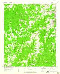
 1958 Gold Mine1960 Print · USGSMarion County during the late 1950s was a landscape of transitioning industries and deep-rooted rural communities. Local historians can trace the development of extraction sites like Gold Mine and Brilliant alongside landmarks such as Bethel Ch and Crooked Creek Cem.4 unique versions available
 - 1960 Map of Gadsden
 1960 Gadsden1960 Print · USGSNorthern Alabama in the mid-1950s is defined by the mighty Tennessee River and its massive reservoirs. Trace the development of Huntsville and Redstone Arsenal or explore the vast William B Bankhead National Forest.2 unique versions available
 - 1963 Map of Gadsden
 1963 Gadsden1963 Print · USGSNorthern Alabama underwent a dramatic mid-century transformation as the Tennessee Valley became a hub for defense and industry. Researchers can trace the development of the Redstone Arsenal, the route of the Natchez Trace Parkway, and long-standing rail lines like the Southern Railway.
 - 1967 Map of Weston, 1968 Print
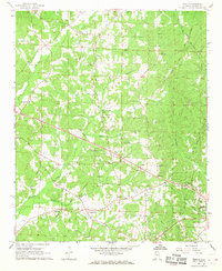 1967 Weston1968 Print · USGSMarion County is seen here in the late sixties as a landscape of rural crossroads and family-run homesteads along the creeks. Researchers can trace ancestral locations at Gravel Springs Sch, Hamilton Cem, and the community at Weston.2 unique versions available
Showing maps 1-25 of 131
Top cities of Marion County
- Hamilton historical maps
- Guin historical maps
- Hackleburg historical maps
- Bear Creek historical maps
- Brilliant historical maps
- Twin historical maps
See more
Frequently asked questions
- What are the different types of historical maps available for Marion County?
- What is the oldest map of Marion County?
- Where can I purchase historical maps of Marion County for my home or office?
- Where can I download high-res historical maps of Marion County?
- Are there historical topographic maps available for Marion County?
- Is there historical aerial imagery available for Marion County?
- Where are historical maps of Marion County sourced from?