1940s Maps of Marion County, Alabama
Explore 5 historic maps of Marion County from the 1940s. These maps offer a rare glimpse into what life looked like during the 1940s — showing old roads, neighborhoods, homes, and landmarks that have changed or disappeared over time.
Whether you're researching your family's past, planning a metal detecting trip, or studying how Marion County's landscape evolved across the 1940s, these high-resolution maps are a powerful tool for exploring the history of this region.
- Focus on a specific era: All maps on this page are from the 1940s, giving you a focused view of this time period.
- See what’s changed: Compare century-old streets, trails, and buildings to today's modern landscape using overlays and satellite layers.
- Research with precision: Use these maps for genealogy, historical research, land use analysis, or educational projects.
- View, download, or print: Maps are fully viewable online in high resolution, and can be downloaded or printed for your own records.
Start exploring Marion County's history through authentic maps from the 1940s. This is your window into the past.
Marion County, AL maps
(5)- 1946 Map of Hackleburg, 1960 Print
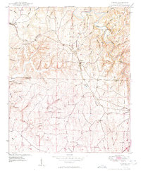
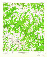 1946 Hackleburg1960 Print · USGSHackleburg and the surrounding Marion County countryside are captured here in the mid-1940s, centered on the Illinois Central Railroad corridor. Researchers can locate early family landmarks like Lawler Cem or trace the old Military Road as it crosses Bear Creek.3 unique versions available
 - 1946 Map of Phil Campbell, 1967 Print
 1946 Phil Campbell1967 Print · USGSNorthwestern Alabama in the mid-1940s reveals a landscape defined by the SOUTHERN rail line and deep mining roots. Trace the locations of early rural schools and churches like Phillips High Sch and Shady Grove Ch, or locate old mines and the Donaldson Mill.3 unique versions available
 - 1947 Map of Phil Campbell
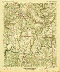 1947 Phil Campbell1947 Print · USGSPhil Campbell and Bear Creek anchor this post-war survey of the Alabama hill country at a time when the Southern railroad still fueled local industry. Researchers can trace rural life through numerous sites like Phillips High Sch, Dime, and the Wilson Mine (Aband).2 unique versions available
 - 1948 Map of Hackleburg
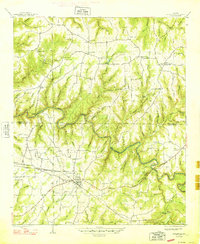 1948 Hackleburg1948 Print · USGSHackleburg and the surrounding rural communities of Northwest Alabama are captured here shortly after the war, centered on the Illinois Central line. You can trace early transit routes along the Military Road and locate family landmarks like Lawler Cem and Gravel Hill School.2 unique versions available
 - 1949 Map of Hodges
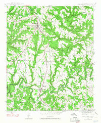
 1949 Hodges1949 Print · USGSNorthwest Alabama at the end of the 1940s reveals a network of small settlements and family landmarks centered on the Illinois Central railroad. Genealogists can trace local roots through sites like Holly Spring Ch, McCurley Cem, and the village of Hodges.2 unique versions available
End of results
Showing maps 1-5 of 5
Top cities of Marion County
- Hamilton historical maps
- Guin historical maps
- Hackleburg historical maps
- Bear Creek historical maps
- Brilliant historical maps
- Twin historical maps
See more
Frequently asked questions
- What are the different types of historical maps available for Marion County?
- What is the oldest map of Marion County?
- Where can I purchase historical maps of Marion County for my home or office?
- Where can I download high-res historical maps of Marion County?
- Are there historical topographic maps available for Marion County?
- Is there historical aerial imagery available for Marion County?
- Where are historical maps of Marion County sourced from?