1980s Maps of Citronelle, Alabama
Explore 6 historic maps of Citronelle from the 1980s. These maps offer a rare glimpse into what life looked like during the 1980s — showing old roads, neighborhoods, homes, and landmarks that have changed or disappeared over time.
Whether you're researching your family's past, planning a metal detecting trip, or studying how Citronelle's landscape evolved across the 1980s, these high-resolution maps are a powerful tool for exploring the history of this region.
- Focus on a specific era: All maps on this page are from the 1980s, giving you a focused view of this time period.
- See what’s changed: Compare century-old streets, trails, and buildings to today's modern landscape using overlays and satellite layers.
- Research with precision: Use these maps for genealogy, historical research, land use analysis, or educational projects.
- View, download, or print: Maps are fully viewable online in high resolution, and can be downloaded or printed for your own records.
Start exploring Citronelle's history through authentic maps from the 1980s. This is your window into the past.
Citronelle, AL maps
(6)- 1982 Map of Citronelle West
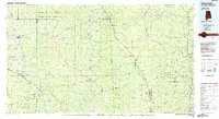
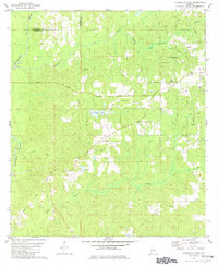 1982 Citronelle West1982 Print · USGSMobile County and Washington County meet at the Esca Tawpa River in the early eighties, where timberlands and oil exploration define the landscape. Genealogists can trace family landmarks like New Hope Cemetery, Bethel Church, and the Oil City Speedway.2 unique versions available
 - 1982 Map of Citronelle East
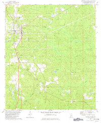 1982 Citronelle East1982 Print · USGSMobile County settlements and petroleum production are captured here in the early eighties. Genealogists and historians can trace family sites like St Annes Cem and Meinhardt Cem alongside the ILLINOIS CENTRAL GULF railroad.2 unique versions available
 - 1982 Map of Deer Park
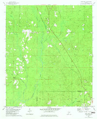 1982 Deer Park1982 Print · USGSThe timber and rail corridor of Washington County is captured here in the early eighties. Researchers can trace the Illinois Central Gulf through Deer Park, locating family landmarks like Weldy Cem and New Light Ch.2 unique versions available
 - 1982 Map of Sims Chapel
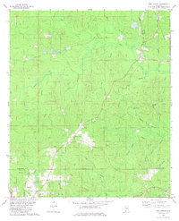 1982 Sims Chapel1982 Print · USGSLower Washington and Mobile counties appear in the early eighties as a landscape of timber, rail, and emerging oil production. Genealogists and local historians can trace the communities of Sims Chapel and Charity Chapel, or locate family sites at Sawyer Cem and Red Wash Cem.
 - 1984 Map of Citronelle
 1984 Citronelle1984 Print · USGSThe Alabama-Mississippi borderlands in the mid-1980s were a hub of timber and rail, spanning from the Leaf River to the Mobile County line. Genealogists can trace family roots through rural communities like Sims Chapel, Leakesville, and Vinegar Bend.2 unique versions available
 - 1984 Map of Hattiesburg
 1984 Hattiesburg1984 Print · USGSSouth Mississippi’s Pine Belt is seen here in the mid-eighties, showing the region as a hub of timber production and petroleum extraction. Trace the rail lines of the Illinois Central Gulf RR through old settlements like Richton or the energy developments at the Heidelberg Oil Field.2 unique versions available
End of results
Showing maps 1-6 of 6
Top cities near Citronelle
- Saraland historical maps
- Satsuma historical maps
- Creola historical maps
- Mount Vernon historical maps
- Movico historical maps
- McIntosh historical maps
Top neighborhoods of Citronelle
Frequently asked questions
- What are the different types of historical maps available for Citronelle?
- What is the oldest map of Citronelle?
- Where can I purchase historical maps of Citronelle for my home or office?
- Where can I download high-res historical maps of Citronelle?
- Are there historical topographic maps available for Citronelle?
- Is there historical aerial imagery available for Citronelle?
- Where are historical maps of Citronelle sourced from?