1990s Maps of Creola, Alabama
Explore 2 historic maps of Creola from the 1990s. These maps offer a rare glimpse into what life looked like during the 1990s — showing old roads, neighborhoods, homes, and landmarks that have changed or disappeared over time.
Whether you're researching your family's past, planning a metal detecting trip, or studying how Creola's landscape evolved across the 1990s, these high-resolution maps are a powerful tool for exploring the history of this region.
- Focus on a specific era: All maps on this page are from the 1990s, giving you a focused view of this time period.
- See what’s changed: Compare century-old streets, trails, and buildings to today's modern landscape using overlays and satellite layers.
- Research with precision: Use these maps for genealogy, historical research, land use analysis, or educational projects.
- View, download, or print: Maps are fully viewable online in high resolution, and can be downloaded or printed for your own records.
Start exploring Creola's history through authentic maps from the 1990s. This is your window into the past.
Creola, AL maps
(2)- 1994 Map of Mobile
 1994 Mobile1994 Print · USGSMobile and its sprawling bay are captured in the mid-nineties as the industrial port and coastal wilderness found a modern balance. Genealogists and historians can trace rail lines like the Illinois Central Gulf RR and find landmarks such as Bonnie Chapel and Hollingers Island.
 - 1997 Map of Hurricane, 2000 Print
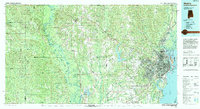
 1997 Hurricane2000 Print · USGSThe Mobile-Tensaw Delta is captured here as the millennium approached, showing a complex waterscape of bayous and historic landings. Researchers can trace the Civil War Trenches near Magnolia Ch or locate old sites like Sizemore Landing and Blakely Sch.
End of results
Showing maps 1-2 of 2
Top cities near Creola
- Mobile historical maps
- Daphne historical maps
- Prichard historical maps
- Saraland historical maps
- Spanish Fort historical maps
- Bay Minette historical maps
See more
Frequently asked questions
- What are the different types of historical maps available for Creola?
- What is the oldest map of Creola?
- Where can I purchase historical maps of Creola for my home or office?
- Where can I download high-res historical maps of Creola?
- Are there historical topographic maps available for Creola?
- Is there historical aerial imagery available for Creola?
- Where are historical maps of Creola sourced from?