1980s Maps of Creola, Alabama
Explore 5 historic maps of Creola from the 1980s. These maps offer a rare glimpse into what life looked like during the 1980s — showing old roads, neighborhoods, homes, and landmarks that have changed or disappeared over time.
Whether you're researching your family's past, planning a metal detecting trip, or studying how Creola's landscape evolved across the 1980s, these high-resolution maps are a powerful tool for exploring the history of this region.
- Focus on a specific era: All maps on this page are from the 1980s, giving you a focused view of this time period.
- See what’s changed: Compare century-old streets, trails, and buildings to today's modern landscape using overlays and satellite layers.
- Research with precision: Use these maps for genealogy, historical research, land use analysis, or educational projects.
- View, download, or print: Maps are fully viewable online in high resolution, and can be downloaded or printed for your own records.
Start exploring Creola's history through authentic maps from the 1980s. This is your window into the past.
Creola, AL maps
(5)- 1980 Map of The Basin, 1981 Print
 1980 The Basin1981 Print · USGSThe Mobile-Tensaw Delta is captured here during the 1980s, revealing a complex network of bayous and river bends. Local historians can locate the Fort Louis Historical Marker and trace the winding paths of Bayou Dead Lake and Bayou Fisher.3 unique versions available
 - 1981 Map of Bay Minette
 1981 Bay Minette1981 Print · USGSThe Alabama-Florida borderlands come to life in the early 1980s as the river delta meets the growing coastal communities. Researchers can trace the Louisville and Nashville rail lines or locate historical points like Twenty-two Mile Bluff and the Blackwater River State Forest.2 unique versions available
 - 1982 Map of Creola
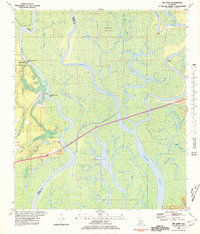
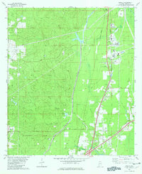 1982 Creola1982 Print · USGSMobile County settlements are mapped in detail during the early eighties as the rail-and-creek landscape of Creola and Axis continued to develop. Genealogists can trace family locations near Forest Lawn Cem, Little Bethel Ch, and the outlying crossroads of Turnerville.3 unique versions available
 - 1984 Map of Mobile
 1984 Mobile1984 Print · USGSMobile and its surrounding Gulf Coast backcountry appear in the mid-eighties as a hub of maritime industry and timber management. Genealogists and historians can trace the development of the riverfront near McDuffie Island or explore rural settlements like Lucedale and Chunchula.
 - 1984 Map of Mobile
 1984 Mobile1984 Print · USGSThe Gulf Coast at the height of the mid-eighties shows a landscape of rapid industrial growth and military significance. Researchers can trace the sprawling rail lines of the Illinois Central Gulf RR, locate the NASA Test Facility, or study the barrier island chain from Cat Island to Petit Bois Island.3 unique versions available
End of results
Showing maps 1-5 of 5
Top cities near Creola
- Mobile historical maps
- Daphne historical maps
- Prichard historical maps
- Saraland historical maps
- Spanish Fort historical maps
- Bay Minette historical maps
See more
Frequently asked questions
- What are the different types of historical maps available for Creola?
- What is the oldest map of Creola?
- Where can I purchase historical maps of Creola for my home or office?
- Where can I download high-res historical maps of Creola?
- Are there historical topographic maps available for Creola?
- Is there historical aerial imagery available for Creola?
- Where are historical maps of Creola sourced from?