1940s Maps of Saraland, Alabama
Explore 5 historic maps of Saraland from the 1940s. These maps offer a rare glimpse into what life looked like during the 1940s — showing old roads, neighborhoods, homes, and landmarks that have changed or disappeared over time.
Whether you're researching your family's past, planning a metal detecting trip, or studying how Saraland's landscape evolved across the 1940s, these high-resolution maps are a powerful tool for exploring the history of this region.
- Focus on a specific era: All maps on this page are from the 1940s, giving you a focused view of this time period.
- See what’s changed: Compare century-old streets, trails, and buildings to today's modern landscape using overlays and satellite layers.
- Research with precision: Use these maps for genealogy, historical research, land use analysis, or educational projects.
- View, download, or print: Maps are fully viewable online in high resolution, and can be downloaded or printed for your own records.
Start exploring Saraland's history through authentic maps from the 1940s. This is your window into the past.
Saraland, AL maps
(5)- 1941 Map of Chickasaw
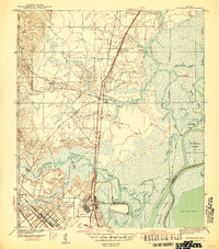 1941 Chickasaw1941 Print · USGSThe industrial riverfront north of Mobile is captured here just before the war, showing the busy Ship Yard and rail hubs. Trace local roots through the early streets of Whistler and Chickasaw or locate family landmarks like Alvarez Bridge and Liveoak Landing.2 unique versions available
 - 1941 Map of Creola, 1959 Print
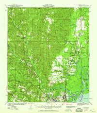 1941 Creola1959 Print · USGSMobile County during the early 1940s was a landscape of rail-connected settlements and coastal bayous. Genealogists can trace family roots through sites like Indian Springs Cem, St Louis Sch, and the riverside town of Creola.3 unique versions available
 - 1942 Map of Kushla
 1942 Kushla1942 Print · USGSMobile County settlements and timberlands appear here just before the mid-century boom. Genealogists can trace the rural communities of Kushla and Mauvilla, finding specific family-history sites like Indian Springs Ch and Kushla Sch along the Gulf Mobile and Ohio rail line.2 unique versions available
 - 1943 Map of Creola
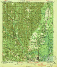 1943 Creola1943 Print · USGSMobile County during the early 1940s shows a landscape of rail-dependent settlements and dense bayous before the mid-century suburban expansion. Researchers can locate family landmarks like Indian Springs Cem, the Oak Grove Sch, and old stops along the Alabama Tennessee and Northern Railroad.2 unique versions available
 - 1943 Map of Chickasaw
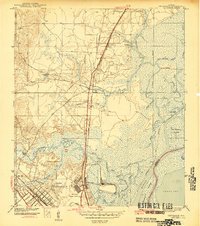 1943 Chickasaw1943 Print · USGSCoastal Alabama was transforming during the early 1940s as industrial and rail networks expanded north of Mobile. Genealogists and historians can trace the early footprints of Saraland and Chickasaw, locate the massive Ship Yard, and study the rail lines of the Southern Railway.3 unique versions available
End of results
Showing maps 1-5 of 5
Top cities near Saraland
- Mobile historical maps
- Daphne historical maps
- Prichard historical maps
- Spanish Fort historical maps
- Satsuma historical maps
- Chickasaw historical maps
See more
Top neighborhoods of Saraland
- Hatters historical maps
- Northwood Estates historical maps
- Pine Wood historical maps
- Kali-Oka Springs historical maps
- Shelton Beach Estates historical maps
- Spanish Trace historical maps
See more
Frequently asked questions
- What are the different types of historical maps available for Saraland?
- What is the oldest map of Saraland?
- Where can I purchase historical maps of Saraland for my home or office?
- Where can I download high-res historical maps of Saraland?
- Are there historical topographic maps available for Saraland?
- Is there historical aerial imagery available for Saraland?
- Where are historical maps of Saraland sourced from?