1940s Maps of Monroe County, Alabama
Explore 4 historic maps of Monroe County from the 1940s. These maps offer a rare glimpse into what life looked like during the 1940s — showing old roads, neighborhoods, homes, and landmarks that have changed or disappeared over time.
Whether you're researching your family's past, planning a metal detecting trip, or studying how Monroe County's landscape evolved across the 1940s, these high-resolution maps are a powerful tool for exploring the history of this region.
- Focus on a specific era: All maps on this page are from the 1940s, giving you a focused view of this time period.
- See what’s changed: Compare century-old streets, trails, and buildings to today's modern landscape using overlays and satellite layers.
- Research with precision: Use these maps for genealogy, historical research, land use analysis, or educational projects.
- View, download, or print: Maps are fully viewable online in high resolution, and can be downloaded or printed for your own records.
Start exploring Monroe County's history through authentic maps from the 1940s. This is your window into the past.
Monroe County, AL maps
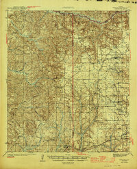
(4)- 1942 Map of Perdido, 1965 Print
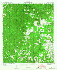 1942 Perdido1965 Print · USGSCoastal Alabama and its inland timberlands are captured here in the early 1940s, showing a transition from remote logging camps to growing railroad towns. Genealogists can locate family landmarks like Steadham Cem, the Langham Lottie Sch, and settlements at Lottie and Nokomis.
 - 1943 Map of Choctaw Bluff, 1958 Print
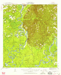 1943 Choctaw Bluff1958 Print · USGSSouthwestern Alabama during the 1940s is shaped by the meeting of the Tombigbee River and Alabama River. Researchers can trace old river landings like Dixie Ldg and find the historic Grave of Red Eagle (Weatherford).2 unique versions available
 - 1944 Map of Perdido
 1944 Perdido1944 Print · USGSCoastal plain settlements and timber country in South Alabama come alive on this mid-forties survey. Trace family history at Lindsey Cem and St Johns Ch, or locate vanished rail stops along the Logging RR and St Louis - San Francisco RR.2 unique versions available
 - 1946 Map of Choctaw Bluff
 1946 Choctaw Bluff1946 Print · USGSThe river-bottom country of southwest Alabama is shown here just after the war, where the mighty Tombigbee and Alabama rivers meet. Researchers can trace historic river landings like Oven Bluff or find the Grave of Red Eagle (Weatherford) near the confluence.2 unique versions available
End of results
Showing maps 1-4 of 4
Top cities of Monroe County
- Monroeville historical maps
- Frisco City historical maps
- Excel historical maps
- Uriah historical maps
- Vredenburgh historical maps
- Beatrice historical maps
Frequently asked questions
- What are the different types of historical maps available for Monroe County?
- What is the oldest map of Monroe County?
- Where can I purchase historical maps of Monroe County for my home or office?
- Where can I download high-res historical maps of Monroe County?
- Are there historical topographic maps available for Monroe County?
- Is there historical aerial imagery available for Monroe County?
- Where are historical maps of Monroe County sourced from?