1970s Maps of Monroe County, Alabama
Explore 22 historic maps of Monroe County from the 1970s. These maps offer a rare glimpse into what life looked like during the 1970s — showing old roads, neighborhoods, homes, and landmarks that have changed or disappeared over time.
Whether you're researching your family's past, planning a metal detecting trip, or studying how Monroe County's landscape evolved across the 1970s, these high-resolution maps are a powerful tool for exploring the history of this region.
- Focus on a specific era: All maps on this page are from the 1970s, giving you a focused view of this time period.
- See what’s changed: Compare century-old streets, trails, and buildings to today's modern landscape using overlays and satellite layers.
- Research with precision: Use these maps for genealogy, historical research, land use analysis, or educational projects.
- View, download, or print: Maps are fully viewable online in high resolution, and can be downloaded or printed for your own records.
Start exploring Monroe County's history through authentic maps from the 1970s. This is your window into the past.
Monroe County, AL maps
(22)- 1971 Map of Skinnerton, 1974 Print
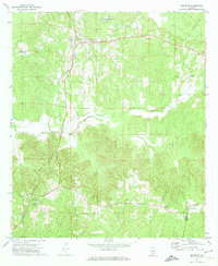
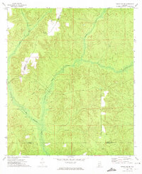
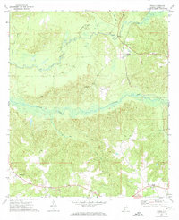
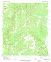 1971 Skinnerton1974 Print · USGSMonroe and Conecuh counties in the early 1970s remained a landscape of timber stands and quiet country crossroads. Genealogists and researchers can locate family-named landmarks and rural congregations like Dene Step Ch, Asbury Ch, and the high-point McWilliams Lookout Tower.2 unique versions available
 - 1971 Map of Burnt Corn, 1974 Print
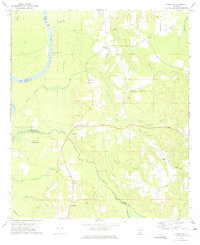
 1971 Burnt Corn1974 Print · USGSThe Monroe and Conecuh county line in the early 1970s reveals a quiet landscape of rural settlements and agricultural crossroads. You can trace the Louisville and Nashville railroad and locate sites like Harpers Store, Burnt Corn, and Pilgrim Rest Ch.
 - 1971 Map of Repton, 1974 Print
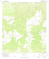
 1971 Repton1974 Print · USGSRepton and its surrounding rural communities are captured here in the early seventies, centered on the Louisville and Nashville railroad corridor. Genealogists can locate several small cemeteries and country houses of worship like Beulah Ch and Oak Grove Ch.2 unique versions available
 - 1971 Map of Bethel, 1974 Print
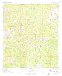
 1971 Bethel1974 Print · USGSConecuh County and its neighbors show a landscape of timber and traditional crossroads in the early seventies. Genealogists can trace family roots through numerous country churches and cemeteries, including Middleton Cem, New Hope Ch, and Mt Zion Ch.
 - 1971 Map of Beatrice, 1974 Print
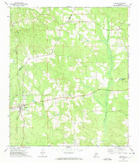
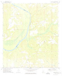
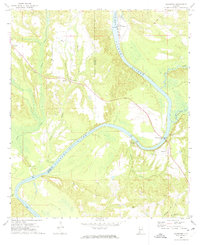
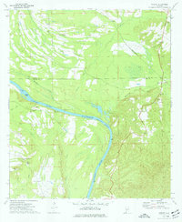
 1971 Beatrice1974 Print · USGSMonroe County, Alabama, in the early seventies was a landscape of rail-connected settlements and winding creek valleys. Genealogists can trace family footprints near Beatrice and Tunnel Springs or locate the Antioch Ch and Greer Jr High Sch.2 unique versions available
 - 1972 Map of Monroeville, 1973 Print
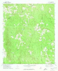
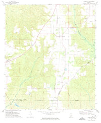
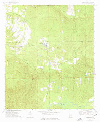
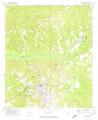 1972 Monroeville1973 Print · USGSMonroeville and its surrounding rural communities are captured here in the early seventies, showing a period of steady growth. Genealogists can trace family connections to rural landmarks like Mt Olive Ch and Antioch Ch or explore the rail corridors of the Louisville and Nashville.2 unique versions available
 - 1972 Map of Frisco City, 1973 Print
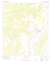 1972 Frisco City1973 Print · USGSMonroe County in the early seventies centers on the rail-to-road transition of its rural communities. Genealogists and historians can trace family locations through numerous landmarks like Lilly Ch, Baas Cem, and the tracks of the St Louis - San Francisco railroad.3 unique versions available
 - 1972 Map of Natchez, 1974 Print
 1972 Natchez1974 Print · USGSMonroe County, Alabama, in the early 1970s reveals a landscape of ridge-top settlements and creek-side rail lines. Researchers can trace the St Louis - San Francisco railroad through Keith or locate family sites near Natchez and Scotland.
 - 1972 Map of Frisco City SE, 1974 Print
 1972 Frisco City SE1974 Print · USGSConecuh County in the early seventies is a landscape of winding watercourses and deep timber history. Researchers can trace the path of an Old Railroad Grade or locate the rural communities of Range and Dean near Big Escambia Creek.2 unique versions available
 - 1972 Map of Uriah East, 1974 Print
 1972 Uriah East1974 Print · USGSMonroe County in the early seventies shows a landscape defined by timber, rail, and early oil exploration. Genealogists can trace local roots through rural landmarks like Oak Grove Ch, Vocation, and the Middle Sch.2 unique versions available
 - 1972 Map of Franklin, 1974 Print
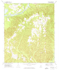 1972 Franklin1974 Print · USGSMonroe County in the early seventies reveals a landscape defined by the Alabama River and isolated rural settlements. Researchers can trace historic river crossings at Davis Ferry or locate small community hubs like Scratch Ankle and Wainwright.2 unique versions available
 - 1972 Map of Excel, 1974 Print
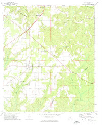 1972 Excel1974 Print · USGSMonroe County's evolving landscape in the early seventies shows the expansion of Excel and the infrastructure of the neighboring county seat. Genealogists and historians can locate rural landmarks like Mt Olive Ch, Halls Crossroads, and the Monroeville Academy.2 unique versions available
 - 1972 Map of Mexia, 1974 Print
 1972 Mexia1974 Print · USGSMonroe County in the early seventies shows a landscape of timberlands and rail-dependent settlements. Genealogists and local historians can trace the paths between Fountain, Mexia, and Perdue Hill or locate the Victoria Ch and Hixon Lookout Tower.2 unique versions available
 - 1972 Map of Chrysler, 1974 Print
 1972 Chrysler1974 Print · USGSMonroe County and the Baldwin county line are mapped here in the early seventies as the river-and-rail landscape was shifting. Genealogists and local historians can locate several family-named landmarks and rural centers, including Eliska, Mamies Chapel, and Shomo Cem.2 unique versions available
 - 1972 Map of Uriah West, 1974 Print
 1972 Uriah West1974 Print · USGSMonroe and Escambia counties in the early 1970s are mapped here during a period of steady rural development and forestry. Genealogists and historians can locate old family landmarks like Semirah Springs Ch, Jenny Bell Hill, and the settlement of Palmers Crossroads.2 unique versions available
 - 1972 Map of Flynns Lake, 1974 Print
 1972 Flynns Lake1974 Print · USGSThe Alabama River corridor at the Monroe and Clarke county line comes to life in this early 1970s survey. Genealogists and researchers can trace historic river access at Dale Ferry Landing and locate rural landmarks like Mt Gilead Ch and Baileys.2 unique versions available
 - 1972 Map of Gainestown, 1975 Print
 1972 Gainestown1975 Print · USGSThe Alabama River dominates this southwest Alabama landscape in the early seventies, where river landings still defined local commerce. Genealogists can trace family roots through sites like Gainestown, Barlow Bend, and the Good Hope Ch Cem.
 - 1972 Map of Claiborne, 1975 Print
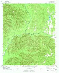
 1972 Claiborne1975 Print · USGSThe Alabama River corridor in the early 1970s reveals a landscape of historic landings and modern engineering. Trace family roots and riverside industry at Gosport Landing, McConnico Cem, and the massive Claiborne Lock and Dam.
 - 1972 Map of Chance, 1975 Print
 1972 Chance1975 Print · USGSThe rural riverlands of Clarke and Monroe Counties are captured here in the early seventies, centered on the Alabama River corridor. Researchers can trace local heritage through landmarks like Finchburg, Fellowship Ch, and Foster Landing.
 - 1973 Map of Hybart, 1977 Print
 1973 Hybart1977 Print · USGSThe Alabama River and Claiborne Lake dominate this 1970s view of the Monroe and Wilcox County line during a period of rural transition. Trace family roots at Packards Bend, Monroe Sch, or old river sites like Kings Log Landing.
 - 1973 Map of Lower Peach Tree, 1977 Print
 1973 Lower Peach Tree1977 Print · USGSThe Alabama River corridor near Lower Peach Tree is captured here during the 1970s as the river system adapted to the creation of Claiborne Lake. Genealogists can locate family landmarks like New Mt Moriah Ch, Kennedy Cem, and the historic Indian Treaty Bdy.
 - 1973 Map of Vredenburgh, 1977 Print
 1973 Vredenburgh1977 Print · USGSVredenburgh and the surrounding Alabama timberlands are captured here in the early seventies during the height of the regional rail era. Genealogists and local historians can trace family sites like Mt Zion Cem, the settlement at Bellview, and churches such as Wayman Chapel.2 unique versions available
End of results
Showing maps 1-22 of 22
Top cities of Monroe County
- Monroeville historical maps
- Frisco City historical maps
- Excel historical maps
- Uriah historical maps
- Vredenburgh historical maps
- Beatrice historical maps
Frequently asked questions
- What are the different types of historical maps available for Monroe County?
- What is the oldest map of Monroe County?
- Where can I purchase historical maps of Monroe County for my home or office?
- Where can I download high-res historical maps of Monroe County?
- Are there historical topographic maps available for Monroe County?
- Is there historical aerial imagery available for Monroe County?
- Where are historical maps of Monroe County sourced from?