
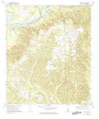
1972 Map of Franklin
USGS Topo · Published 1974About this map
The Alabama River winds through the northern portion of this Monroe County landscape, defining a region where river-based transport and rural church life intersect. This early 1970s survey shows the winding course of the water past Haines Island and Bates Bar, with Davis Ferry and Leggett Landing serving as vital access points. The interior is characterized by a high density of country churches and small community centers, including the uniquely named Scratch Ankle and the settlement of Franklin. Numerous creek systems like Bradley Mill Creek and Holly Mill Creek drain the dissected uplands, while several named houses of worship, such as Mt Ararat Ch, Miles Chapel, and Eureka Ch, suggest a long-established social fabric rooted in these hills. Genealogists may find particular value in locating the York Cem and various unnamed cemeteries scattered near these community hubs.
Find a feature on this map
24 named features on this map. Tap any name to fly to it.
Don’t see what you’re looking for? This feature index may not catch every label — zoom into the map to look around manually.
Map Details
Editions of this 1972 Franklin Map
2 editions found
Other maps of this area

1953 · Andalusia
USGS Topo · 1:250,000

1957 · Andalusia
USGS Topo · 1:250,000

1972 · Monroeville
USGS Topo · 1:24,000

1972 · Natchez
USGS Topo · 1:24,000

1972 · Mexia
USGS Topo · 1:24,000

1972 · Claiborne
USGS Topo · 1:24,000

1972 · Chance
USGS Topo · 1:24,000

1973 · Hybart
USGS Topo · 1:24,000

1973 · Lower Peach Tree
USGS Topo · 1:24,000

1973 · Vredenburgh
USGS Topo · 1:24,000