1930s Maps of Decatur, Alabama
Explore 6 historic maps of Decatur from the 1930s. These maps offer a rare glimpse into what life looked like during the 1930s — showing old roads, neighborhoods, homes, and landmarks that have changed or disappeared over time.
Whether you're researching your family's past, planning a metal detecting trip, or studying how Decatur's landscape evolved across the 1930s, these high-resolution maps are a powerful tool for exploring the history of this region.
- Focus on a specific era: All maps on this page are from the 1930s, giving you a focused view of this time period.
- See what’s changed: Compare century-old streets, trails, and buildings to today's modern landscape using overlays and satellite layers.
- Research with precision: Use these maps for genealogy, historical research, land use analysis, or educational projects.
- View, download, or print: Maps are fully viewable online in high resolution, and can be downloaded or printed for your own records.
Start exploring Decatur's history through authentic maps from the 1930s. This is your window into the past.
Decatur, AL maps
(6)- 1936 Map of Hartselle
 1936 Hartselle1936 Print · USGSHartselle and the surrounding Morgan County countryside are captured here during the mid-1930s as the Tennessee Valley Authority began reshaping the landscape. Genealogists and local historians can trace rural communities through CCC Camp No 3485, Natural Bridge Sch, and Liberty Cem.
 - 1936 Map of Decatur
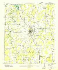
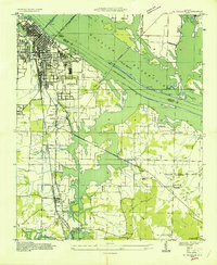 1936 Decatur1936 Print · USGSDecatur and the Tennessee River valley are captured here during the transformative years of the Tennessee Valley Authority. Trace early neighborhoods and rural landmarks like Blackwell Cem, Priceville Sch, and the Brick Kilns.
 - 1936 Map of Stewart Cross Roads
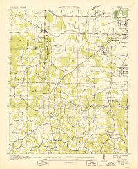
 1936 Stewart Cross Roads1936 Print · USGSThe Tennessee River valley underwent a massive transformation in the mid-1930s as the new reservoir flooded the lowlands. You can trace submerged riverbanks and find upland landmarks like Stewart Cross Roads, Beulah Land, and St Luke Sch.
 - 1936 Map of Trinity
 1936 Trinity1936 Print · USGSThe Tennessee River valley near the Lawrence and Morgan county line is captured here just as the new reservoir system was taking shape. Genealogists can trace family names at Roselawn Cem, find old rural schools like Means Sch, and locate the historic Kirby Bridge.
 - 1936 Map of Tanner
 1936 Tanner1936 Print · USGSLimestone County is captured during the transformative years of the Tennessee Valley Authority project. Researchers can trace family sites and rural landmarks like Mooresville, Taylor Pride Cem, and the Alabama State Farm near the rising waters of Wheeler Reservoir.
 - 1938 Map of Tanner
 1938 Tanner1938 Print · USGSLimestone County in the late thirties shows a landscape transformed by the new Wheeler Reservoir and its rising waters. Genealogists can trace family holdings and community hubs like Anderson Plantation, Taylor Pride Cem, and Mooresville.
End of results
Showing maps 1-6 of 6
Top cities near Decatur
- Huntsville historical maps
- Madison historical maps
- Athens historical maps
- Hartselle historical maps
- Priceville historical maps
- Trinity historical maps
See more
Top neighborhoods of Decatur
- Crowtown historical maps
- Albany historical maps
- West Decatur historical maps
- Burningtree Estates historical maps
- Burningtree Mountain historical maps
- Cedar Lake historical maps
See more
Frequently asked questions
- What are the different types of historical maps available for Decatur?
- What is the oldest map of Decatur?
- Where can I purchase historical maps of Decatur for my home or office?
- Where can I download high-res historical maps of Decatur?
- Are there historical topographic maps available for Decatur?
- Is there historical aerial imagery available for Decatur?
- Where are historical maps of Decatur sourced from?