1970s Maps of Decatur, Alabama
Explore 2 historic maps of Decatur from the 1970s. These maps offer a rare glimpse into what life looked like during the 1970s — showing old roads, neighborhoods, homes, and landmarks that have changed or disappeared over time.
Whether you're researching your family's past, planning a metal detecting trip, or studying how Decatur's landscape evolved across the 1970s, these high-resolution maps are a powerful tool for exploring the history of this region.
- Focus on a specific era: All maps on this page are from the 1970s, giving you a focused view of this time period.
- See what’s changed: Compare century-old streets, trails, and buildings to today's modern landscape using overlays and satellite layers.
- Research with precision: Use these maps for genealogy, historical research, land use analysis, or educational projects.
- View, download, or print: Maps are fully viewable online in high resolution, and can be downloaded or printed for your own records.
Start exploring Decatur's history through authentic maps from the 1970s. This is your window into the past.
Decatur, AL maps
(2)- 1975 Map of Decatur, 1976 Print
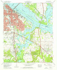 1975 Decatur1976 Print · USGSDecatur and the Tennessee River valley are shown in the mid-seventies during a period of steady southward expansion. Genealogists and historians can trace family locations at Blackwell Cem or Pisgah Cem, while locating the historic rail lines of the Southern and Louisville and Nashville.3 unique versions available
 - 1976 Map of Jones Crossroads, 1977 Print
 1976 Jones Crossroads1977 Print · USGSThe Tennessee River valley north of Decatur underwent significant industrial transformation by the mid-seventies. Researchers can trace family history through numerous burial sites like Malone Cem or locate the sprawling Browns Ferry Nuclear Plant.
End of results
Showing maps 1-2 of 2
Top cities near Decatur
- Huntsville historical maps
- Madison historical maps
- Athens historical maps
- Hartselle historical maps
- Priceville historical maps
- Trinity historical maps
See more
Top neighborhoods of Decatur
- Crowtown historical maps
- Albany historical maps
- West Decatur historical maps
- Burningtree Estates historical maps
- Burningtree Mountain historical maps
- Cedar Lake historical maps
See more
Frequently asked questions
- What are the different types of historical maps available for Decatur?
- What is the oldest map of Decatur?
- Where can I purchase historical maps of Decatur for my home or office?
- Where can I download high-res historical maps of Decatur?
- Are there historical topographic maps available for Decatur?
- Is there historical aerial imagery available for Decatur?
- Where are historical maps of Decatur sourced from?