1960s Maps of Reform, Alabama
Explore 5 historic maps of Reform from the 1960s. These maps offer a rare glimpse into what life looked like during the 1960s — showing old roads, neighborhoods, homes, and landmarks that have changed or disappeared over time.
Whether you're researching your family's past, planning a metal detecting trip, or studying how Reform's landscape evolved across the 1960s, these high-resolution maps are a powerful tool for exploring the history of this region.
- Focus on a specific era: All maps on this page are from the 1960s, giving you a focused view of this time period.
- See what’s changed: Compare century-old streets, trails, and buildings to today's modern landscape using overlays and satellite layers.
- Research with precision: Use these maps for genealogy, historical research, land use analysis, or educational projects.
- View, download, or print: Maps are fully viewable online in high resolution, and can be downloaded or printed for your own records.
Start exploring Reform's history through authentic maps from the 1960s. This is your window into the past.
Reform, AL maps
(5)- 1963 Map of West Point
 1963 West Point1963 Print · USGSEastern Mississippi and western Alabama are captured in the early sixties as industrial centers and rail lines connected the Black Prairie to the hills. Genealogists and historians can trace family-named watercourses and the early footprints of Starkville, Columbus, and the Noxubee National Wildlife Refuge.2 unique versions available
 - 1967 Map of Carrollton
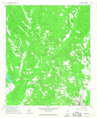
 1967 Carrollton1967 Print · USGSPickens County comes into focus during the late sixties as the regional rail and road networks centered on Carrollton matured. Researchers can trace family history through sites like Cockrell Cem, New Providence Ch, and the old ICG railroad corridor.3 unique versions available
 - 1967 Map of Gordo, 1968 Print
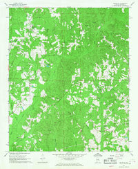
 1967 Gordo1968 Print · USGSIn late 1960s Pickens County, the town of Gordo and the settlement of Lathrop stood at a crossroads of rail history and modern highway expansion. Researchers can trace numerous family-named landmarks like Arbor Springs Ch, Linebarger Cem, and the Lathrop Lookout Tower.2 unique versions available
 - 1967 Map of Palmetto, 1968 Print
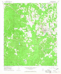
 1967 Palmetto1968 Print · USGSPickens County was a landscape of creek-side settlements and rural churches during the late 1960s. Genealogists can locate family landmarks like Mt Tabor Cem and Unity Grove Ch, or trace the winding courses of Lubbub Creek and Holly Creek.2 unique versions available
 - 1967 Map of Reform, 1968 Print
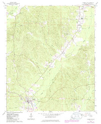
 1967 Reform1968 Print · USGSReform and the surrounding Pickens County countryside appear here in the late sixties as the local railroad economy remained in full swing. Genealogists can locate family landmarks like Hopewell Cem, Christian Hope Ch, and the Gulf Mobile and Ohio rail line.3 unique versions available
End of results
Showing maps 1-5 of 5
Top cities near Reform
- Aliceville historical maps
- Gordo historical maps
- Carrollton historical maps
- Millport historical maps
- Pickensville historical maps
- Kennedy historical maps
See more
Top neighborhoods of Reform
Frequently asked questions
- What are the different types of historical maps available for Reform?
- What is the oldest map of Reform?
- Where can I purchase historical maps of Reform for my home or office?
- Where can I download high-res historical maps of Reform?
- Are there historical topographic maps available for Reform?
- Is there historical aerial imagery available for Reform?
- Where are historical maps of Reform sourced from?