1980s Maps of Pell City, Alabama
Explore 3 historic maps of Pell City from the 1980s. These maps offer a rare glimpse into what life looked like during the 1980s — showing old roads, neighborhoods, homes, and landmarks that have changed or disappeared over time.
Whether you're researching your family's past, planning a metal detecting trip, or studying how Pell City's landscape evolved across the 1980s, these high-resolution maps are a powerful tool for exploring the history of this region.
- Focus on a specific era: All maps on this page are from the 1980s, giving you a focused view of this time period.
- See what’s changed: Compare century-old streets, trails, and buildings to today's modern landscape using overlays and satellite layers.
- Research with precision: Use these maps for genealogy, historical research, land use analysis, or educational projects.
- View, download, or print: Maps are fully viewable online in high resolution, and can be downloaded or printed for your own records.
Start exploring Pell City's history through authentic maps from the 1980s. This is your window into the past.
Pell City, AL maps
(3)- 1984 Map of Birmingham South, 1985 Print
 1984 Birmingham South1985 Print · USGSThe Birmingham metropolitan region and the Coosa River valley are shown here in the mid-eighties as suburban growth expanded south into the ridges. Genealogists and local historians can trace the development of communities from Bessemer to Sylacauga alongside the Lay Lake shoreline and the Talladega National Forest.2 unique versions available
 - 1984 Map of Birmingham North, 1985 Print
 1984 Birmingham North1985 Print · USGSNorth Alabama in the mid-eighties shows the bustling intersection of the Appalachian foothills and the Deep South's industrial heart. Genealogists and historians can trace the paths of the Southern Railway and Seaboard System Railroad through towns like Oneonta, Leeds, and Springville.2 unique versions available
 - 1987 Map of Sleeping Giants
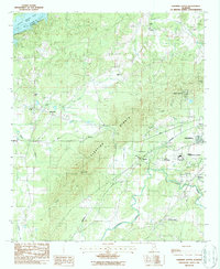 1987 Sleeping Giants1987 Print · USGSThe Talladega area in the late 1980s is defined by the ridge of the Sleeping Giants and a busy rail corridor. Local historians can trace family landmarks like Howard Chapel, Antioch Ch, and the Midway Memorial Gardens.
End of results
Showing maps 1-3 of 3
Top cities near Pell City
- Talladega historical maps
- Moody historical maps
- Lincoln historical maps
- Margaret historical maps
- Odenville historical maps
- Springville historical maps
See more
Top neighborhoods of Pell City
- Pine Orchard historical maps
- Stemley Cove historical maps
- Catatoga Estates historical maps
- Lakeview historical maps
- Carl Smith Subdivision historical maps
- Cropwell historical maps
See more
Frequently asked questions
- What are the different types of historical maps available for Pell City?
- What is the oldest map of Pell City?
- Where can I purchase historical maps of Pell City for my home or office?
- Where can I download high-res historical maps of Pell City?
- Are there historical topographic maps available for Pell City?
- Is there historical aerial imagery available for Pell City?
- Where are historical maps of Pell City sourced from?