1970s Maps of Pell City, Alabama
Explore 5 historic maps of Pell City from the 1970s. These maps offer a rare glimpse into what life looked like during the 1970s — showing old roads, neighborhoods, homes, and landmarks that have changed or disappeared over time.
Whether you're researching your family's past, planning a metal detecting trip, or studying how Pell City's landscape evolved across the 1970s, these high-resolution maps are a powerful tool for exploring the history of this region.
- Focus on a specific era: All maps on this page are from the 1970s, giving you a focused view of this time period.
- See what’s changed: Compare century-old streets, trails, and buildings to today's modern landscape using overlays and satellite layers.
- Research with precision: Use these maps for genealogy, historical research, land use analysis, or educational projects.
- View, download, or print: Maps are fully viewable online in high resolution, and can be downloaded or printed for your own records.
Start exploring Pell City's history through authentic maps from the 1970s. This is your window into the past.
Pell City, AL maps
(5)- 1975 Map of Laniers, 1976 Print
 1975 Laniers1976 Print · USGSThe Alabama landscape near the Coosa River is captured in the mid-seventies just as the shoreline began to develop. Researchers can trace the winding branches of Logan Martin Lake and locate the small settlement of Laniers amidst the woods and fields.
 - 1975 Map of Riverside, 1977 Print
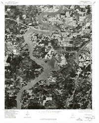 1975 Riverside1977 Print · USGSIn the mid-seventies, the waters of Logan Martin Lake had recently transformed the St. Clair County landscape. Trace the shoreline development and transportation crossings near Riverside as they appeared just over a decade after the dam was completed.
 - 1975 Map of Talladega NW, 1977 Print
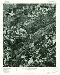 1975 Talladega NW1977 Print · USGSMid-1970s Alabama comes into focus in this aerial survey, capturing the industrial and riverine character of the Talladega area. Local researchers can trace the development of Bemiston and examine the banks of the Coosa River at this moment in time.
 - 1975 Map of Pell City, 1977 Print
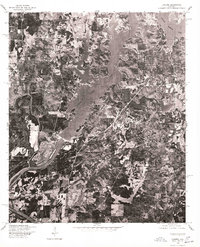
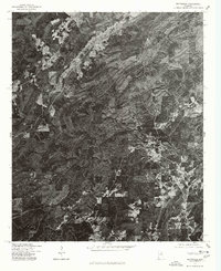
 1975 Pell City1977 Print · USGSPell City and the northern reaches of the Coosa River valley are captured in high-detail aerial imagery during the mid-seventies. Researchers can trace the development of the shoreline along Logan Martin Lake and the expanding footprint of Pell City.
 - 1975 Map of Wattsville, 1977 Print
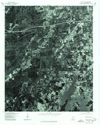
 1975 Wattsville1977 Print · USGSCovers Pell City, including Odenville, Coal City, and other nearby areas
End of results
Showing maps 1-5 of 5
Top cities near Pell City
- Talladega historical maps
- Moody historical maps
- Lincoln historical maps
- Margaret historical maps
- Odenville historical maps
- Springville historical maps
See more
Top neighborhoods of Pell City
- Pine Orchard historical maps
- Stemley Cove historical maps
- Catatoga Estates historical maps
- Lakeview historical maps
- Carl Smith Subdivision historical maps
- Cropwell historical maps
See more
Frequently asked questions
- What are the different types of historical maps available for Pell City?
- What is the oldest map of Pell City?
- Where can I purchase historical maps of Pell City for my home or office?
- Where can I download high-res historical maps of Pell City?
- Are there historical topographic maps available for Pell City?
- Is there historical aerial imagery available for Pell City?
- Where are historical maps of Pell City sourced from?