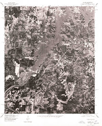
1975 Map of Laniers
USGS Topo · Published 1976About this map
Logan Martin Lake dominates this mid-1970s orthophotograph, its intricate, branching fingers spreading through the Alabama landscape. Created by the Soil Conservation Service and the U.S. Geological Survey using aerial photography taken in December 1975, this map provides a detailed look at the interface between the reservoir and the surrounding rural community. The settlement of Laniers appears near the southern reaches of the map, situated above the winding Coosa River. The imagery reveals a landscape of wooded hills, agricultural clearings, and the developing shoreline of the lake, capturing the local geography as it existed just over a decade after the damming of the river. This specific edition uses rectified photoimagery rather than traditional topographic contour lines, allowing for the direct visual study of land use, forest cover, and the precise road networks connecting the scattered homes and farms of the era.
Find a feature on this map
3 named features on this map. Tap any name to fly to it.
Don’t see what you’re looking for? This feature index may not catch every label — zoom into the map to look around manually.
Map Details
Editions of this 1975 Laniers Map
This is the sole edition of this map. No revisions or reprints were ever made.
Other maps of this area

1889 · Springville
USGS Topo · 1:125,000

1890 · Talladega
USGS Topo · 1:125,000

1892 · Springville
USGS Topo · 1:125,000

1892 · Talladega
USGS Topo · 1:125,000

1943 · Talladega
USGS Topo · 1:62,500

1946 · Talladega
USGS Topo · 1:62,500

1947 · Ragland
USGS Topo · 1:62,500

1947 · Riverside
USGS Topo · 1:24,000

1951 · Vincent
USGS Topo · 1:24,000

1951 · Laniers
USGS Topo · 1:24,000