1970s Maps of Ragland, Alabama
Explore 4 historic maps of Ragland from the 1970s. These maps offer a rare glimpse into what life looked like during the 1970s — showing old roads, neighborhoods, homes, and landmarks that have changed or disappeared over time.
Whether you're researching your family's past, planning a metal detecting trip, or studying how Ragland's landscape evolved across the 1970s, these high-resolution maps are a powerful tool for exploring the history of this region.
- Focus on a specific era: All maps on this page are from the 1970s, giving you a focused view of this time period.
- See what’s changed: Compare century-old streets, trails, and buildings to today's modern landscape using overlays and satellite layers.
- Research with precision: Use these maps for genealogy, historical research, land use analysis, or educational projects.
- View, download, or print: Maps are fully viewable online in high resolution, and can be downloaded or printed for your own records.
Start exploring Ragland's history through authentic maps from the 1970s. This is your window into the past.
Ragland, AL maps
(4)- 1975 Map of Ohatchee, 1977 Print
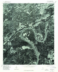
 1975 Ohatchee1977 Print · USGSThe Coosa River valley in the mid-1970s reveals a landscape defined by its major reservoirs. Trace the shoreline of H Neely Henry Lake and the settlement of Ohatchee as they appeared just before the close of the decade.
 - 1975 Map of Francis Mill, 1977 Print
 1975 Francis Mill1977 Print · USGSCalhoun County in the mid-1970s is shown here through detailed aerial imagery rather than standard line drawings. Trace rural property lines and land use patterns near the Coosa River and the small settlement of Francis Mill.
 - 1975 Map of Ragland, 1977 Print
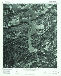
 1975 Ragland1977 Print · USGSThe town of Ragland and the surrounding St. Clair County riverfront are shown in detail during the mid-seventies. Researchers can trace the exact shoreline of Logan Martin Lake and the winding path of the Coosa River from actual aerial photography.
 - 1975 Map of Cox Gap, 1977 Print
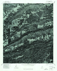 1975 Cox Gap1977 Print · USGSNear the town of Ashville in the mid-1970s, the rural Alabama landscape is defined by its dramatic ridges and agricultural clearings. Researchers can trace the path of the local Creek and examine field boundaries and early road networks across St. Clair County.
End of results
Showing maps 1-4 of 4
Top cities near Ragland
- Gadsden historical maps
- Oxford historical maps
- Anniston historical maps
- Pell City historical maps
- Rainbow City historical maps
- Southside historical maps
See more
Frequently asked questions
- What are the different types of historical maps available for Ragland?
- What is the oldest map of Ragland?
- Where can I purchase historical maps of Ragland for my home or office?
- Where can I download high-res historical maps of Ragland?
- Are there historical topographic maps available for Ragland?
- Is there historical aerial imagery available for Ragland?
- Where are historical maps of Ragland sourced from?