1970s Maps of York, Alabama
Explore 2 historic maps of York from the 1970s. These maps offer a rare glimpse into what life looked like during the 1970s — showing old roads, neighborhoods, homes, and landmarks that have changed or disappeared over time.
Whether you're researching your family's past, planning a metal detecting trip, or studying how York's landscape evolved across the 1970s, these high-resolution maps are a powerful tool for exploring the history of this region.
- Focus on a specific era: All maps on this page are from the 1970s, giving you a focused view of this time period.
- See what’s changed: Compare century-old streets, trails, and buildings to today's modern landscape using overlays and satellite layers.
- Research with precision: Use these maps for genealogy, historical research, land use analysis, or educational projects.
- View, download, or print: Maps are fully viewable online in high resolution, and can be downloaded or printed for your own records.
Start exploring York's history through authentic maps from the 1970s. This is your window into the past.
York, AL maps
(2)- 1974 Map of Boyd, 1978 Print
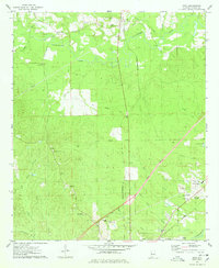 1974 Boyd1978 Print · USGSSumter County at the peak of the 1970s shows the convergence of major rail lines and rural river life. Genealogists and historians can trace numerous family sites like Elliott Cem, Smiths Chapel, and the vanished Old Railroad Grade near Boyd.2 unique versions available
 - 1974 Map of York, 1978 Print
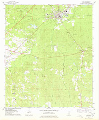 1974 York1978 Print · USGSSumter County in the mid-seventies shows a landscape of timbered hills and rail junctions centered on the hub of York. Researchers can trace old family sites and rural landmarks like the Kinterbish Jr High Sch, Siloam Ch, and the Rumley Lookout Tower.
End of results
Showing maps 1-2 of 2
Top cities near York
- Livingston historical maps
- Bellamy historical maps
- Cuba historical maps
- Epes historical maps
- Emelle historical maps
Frequently asked questions
- What are the different types of historical maps available for York?
- What is the oldest map of York?
- Where can I purchase historical maps of York for my home or office?
- Where can I download high-res historical maps of York?
- Are there historical topographic maps available for York?
- Is there historical aerial imagery available for York?
- Where are historical maps of York sourced from?