1940s Maps of Eureka Shores, Lincoln
Explore 2 historic maps of Eureka Shores from the 1940s. These maps offer a rare glimpse into what life looked like during the 1940s — showing old roads, neighborhoods, homes, and landmarks that have changed or disappeared over time.
Whether you're researching your family's past, planning a metal detecting trip, or studying how Eureka Shores's landscape evolved across the 1940s, these high-resolution maps are a powerful tool for exploring the history of this region.
- Focus on a specific era: All maps on this page are from the 1940s, giving you a focused view of this time period.
- See what’s changed: Compare century-old streets, trails, and buildings to today's modern landscape using overlays and satellite layers.
- Research with precision: Use these maps for genealogy, historical research, land use analysis, or educational projects.
- View, download, or print: Maps are fully viewable online in high resolution, and can be downloaded or printed for your own records.
Start exploring Eureka Shores's history through authentic maps from the 1940s. This is your window into the past.
Eureka Shores, Lincoln maps
(2)- 1947 Map of Ragland, 1953 Print
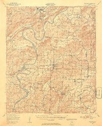 1947 Ragland1953 Print · USGSIn the late 1940s, the Coosa River valley was a landscape of deep-rooted rural communities and growing military installations. Genealogists can trace family landmarks like Rhodes Chapel and old mills such as Martins Mill or Francis Mill.3 unique versions available
 - 1947 Map of Riverside, 1953 Print
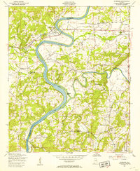 1947 Riverside1953 Print · USGSRiverside and the riverbanks of St. Clair and Talladega counties appear here just after the war, when the railroad and river still dictated the local economy. Genealogists can locate family landmarks like Seddon Cem, Idelia Sch, and the riverside Lock No 5 (Abandoned).4 unique versions available
End of results
Showing maps 1-2 of 2
Top cities near Eureka Shores
- Oxford historical maps
- Talladega historical maps
- Pell City historical maps
- Lincoln historical maps
- Odenville historical maps
- Springville historical maps
See more
Frequently asked questions
- What are the different types of historical maps available for Eureka Shores?
- What is the oldest map of Eureka Shores?
- Where can I purchase historical maps of Eureka Shores for my home or office?
- Where can I download high-res historical maps of Eureka Shores?
- Are there historical topographic maps available for Eureka Shores?
- Is there historical aerial imagery available for Eureka Shores?
- Where are historical maps of Eureka Shores sourced from?