1960s Maps of Tallapoosa County, Alabama
Explore 4 historic maps of Tallapoosa County from the 1960s. These maps offer a rare glimpse into what life looked like during the 1960s — showing old roads, neighborhoods, homes, and landmarks that have changed or disappeared over time.
Whether you're researching your family's past, planning a metal detecting trip, or studying how Tallapoosa County's landscape evolved across the 1960s, these high-resolution maps are a powerful tool for exploring the history of this region.
- Focus on a specific era: All maps on this page are from the 1960s, giving you a focused view of this time period.
- See what’s changed: Compare century-old streets, trails, and buildings to today's modern landscape using overlays and satellite layers.
- Research with precision: Use these maps for genealogy, historical research, land use analysis, or educational projects.
- View, download, or print: Maps are fully viewable online in high resolution, and can be downloaded or printed for your own records.
Start exploring Tallapoosa County's history through authentic maps from the 1960s. This is your window into the past.
Tallapoosa County, AL maps
(4)- 1969 Map of New Site, 1973 Print
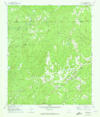 1969 New Site1973 Print · USGSTallapoosa County's rural heartland is meticulously documented in this late 1960s survey as small communities like Goldville and New Site began to modernize. Genealogists and historians can trace long-standing landmarks such as Old Salem Cem, Bethlehem Ch, and the isolated Fosheeton settlement.
 - 1969 Map of Hackneyville, 1973 Print
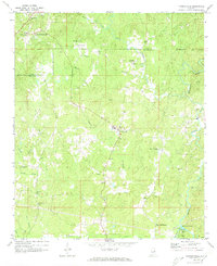 1969 Hackneyville1973 Print · USGSTallapoosa and Clay counties come into focus in the late sixties, revealing a rural network of crossroads and creek-side settlements. Family historians can trace ancestral sites like Old Providence Cem, New Hope Ch, and the community hub at Hackneyville.2 unique versions available
 - 1969 Map of Daviston, 1973 Print
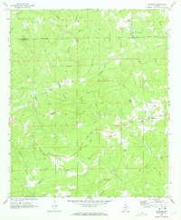 1969 Daviston1973 Print · USGSThe rural borderlands of Tallapoosa and Clay counties come into focus during the late 1960s. Researchers can trace local heritage through sites like the Zana Training School, the Old Vickers Cemetery, and the Rocky Mount Lookout Tower.
 - 1969 Map of Wadley South, 1973 Print
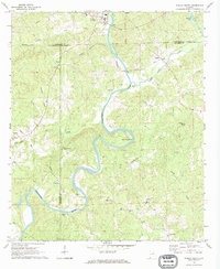 1969 Wadley South1973 Print · USGSThe Tallapoosa River valley in eastern Alabama was a region of remote crossroads and river bends in the late sixties. Genealogists and local historians can trace the foundations of communities like Frog Eye, Abanda, and the family-named Sims Cem or Bibbys Ferry.
End of results
Showing maps 1-4 of 4
Top cities of Tallapoosa County
- Alexander City historical maps
- Dadeville historical maps
- Camp Hill historical maps
- Reeltown historical maps
- New Site historical maps
- Jacksons' Gap historical maps
See more
Frequently asked questions
- What are the different types of historical maps available for Tallapoosa County?
- What is the oldest map of Tallapoosa County?
- Where can I purchase historical maps of Tallapoosa County for my home or office?
- Where can I download high-res historical maps of Tallapoosa County?
- Are there historical topographic maps available for Tallapoosa County?
- Is there historical aerial imagery available for Tallapoosa County?
- Where are historical maps of Tallapoosa County sourced from?