1930s Maps of Haleyville, Alabama
Explore 4 historic maps of Haleyville from the 1930s. These maps offer a rare glimpse into what life looked like during the 1930s — showing old roads, neighborhoods, homes, and landmarks that have changed or disappeared over time.
Whether you're researching your family's past, planning a metal detecting trip, or studying how Haleyville's landscape evolved across the 1930s, these high-resolution maps are a powerful tool for exploring the history of this region.
- Focus on a specific era: All maps on this page are from the 1930s, giving you a focused view of this time period.
- See what’s changed: Compare century-old streets, trails, and buildings to today's modern landscape using overlays and satellite layers.
- Research with precision: Use these maps for genealogy, historical research, land use analysis, or educational projects.
- View, download, or print: Maps are fully viewable online in high resolution, and can be downloaded or printed for your own records.
Start exploring Haleyville's history through authentic maps from the 1930s. This is your window into the past.
Haleyville, AL maps
(4)- 1936 Map of Delmar
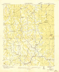
 1936 Delmar1936 Print · USGSHaleyville and the surrounding Winston County terrain are captured here in the mid-1930s as modern infrastructure reached the region. Genealogists and historians can trace the early road network of State Highway No 5 and locate landmarks like Prospect Ch and Quarter Creek.
 - 1936 Map of Kinlock Spring
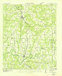
 1936 Kinlock Spring1936 Print · USGSWinston and Franklin Counties were transitioning into a new era of federal land management and infrastructure during the mid-thirties. Genealogists can locate family-named landmarks like Posey Mill, Carrolls Cross Roads, and the CCC Camp No F 3 near the National Forest boundary.
 - 1936 Map of Phil Campbell
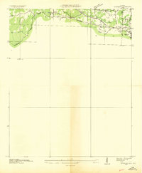
 1936 Phil Campbell1936 Print · USGSNorthwest Alabama at the height of the mid-thirties shows a landscape of ridge-top settlements and creek-side industry. Genealogists can trace family roots through numerous rural landmarks like Morris Hill Ch, Phillips Sch, and the Lowler Mines.
 - 1936 Map of Goddard
 1936 Goddard1936 Print · USGSNorthern Alabama's ridgeline terrain is documented in the mid-1930s, showing the intersection of heavy rail and forest boundaries. Genealogists can locate Union Grove Ch and Goddard near the Southern rail line and Black Warrior National Forest.
End of results
Showing maps 1-4 of 4
Top cities near Haleyville
- Guin historical maps
- Hackleburg historical maps
- Double Springs historical maps
- Bear Creek historical maps
- Phil Campbell historical maps
- Brilliant historical maps
See more
Frequently asked questions
- What are the different types of historical maps available for Haleyville?
- What is the oldest map of Haleyville?
- Where can I purchase historical maps of Haleyville for my home or office?
- Where can I download high-res historical maps of Haleyville?
- Are there historical topographic maps available for Haleyville?
- Is there historical aerial imagery available for Haleyville?
- Where are historical maps of Haleyville sourced from?