1960s Maps of Highland Park, North Pole
Explore 2 historic maps of Highland Park from the 1960s. These maps offer a rare glimpse into what life looked like during the 1960s — showing old roads, neighborhoods, homes, and landmarks that have changed or disappeared over time.
Whether you're researching your family's past, planning a metal detecting trip, or studying how Highland Park's landscape evolved across the 1960s, these high-resolution maps are a powerful tool for exploring the history of this region.
- Focus on a specific era: All maps on this page are from the 1960s, giving you a focused view of this time period.
- See what’s changed: Compare century-old streets, trails, and buildings to today's modern landscape using overlays and satellite layers.
- Research with precision: Use these maps for genealogy, historical research, land use analysis, or educational projects.
- View, download, or print: Maps are fully viewable online in high resolution, and can be downloaded or printed for your own records.
Start exploring Highland Park's history through authentic maps from the 1960s. This is your window into the past.
Highland Park, North Pole maps
(2)- 1964 Map of Fairbanks
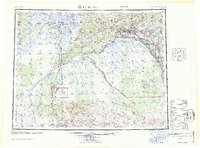 1964 Fairbanks1964 Print · USGSInterior Alaska in the mid-1960s centered on the growing hub of Fairbanks and its strategic military and rail connections. Genealogists and historians can trace the paths of The Alaska Railroad through Nenana or locate Placer Mines near Murphy Dome and Ester.
 - 1966 Map of Fairbanks D-1 SW, 1970 Print
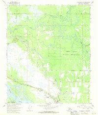 1966 Fairbanks D-1 SW1970 Print · USGSThe Fairbanks area in the mid-sixties reveals a landscape defined by meandering rivers and growing military and civilian infrastructure. Local historians can trace early developments at North Pole and Highland Park or locate aviation landmarks like the Bradley Sky Ranch.2 unique versions available
End of results
Showing maps 1-2 of 2
Top cities near Highland Park
Frequently asked questions
- What are the different types of historical maps available for Highland Park?
- What is the oldest map of Highland Park?
- Where can I purchase historical maps of Highland Park for my home or office?
- Where can I download high-res historical maps of Highland Park?
- Are there historical topographic maps available for Highland Park?
- Is there historical aerial imagery available for Highland Park?
- Where are historical maps of Highland Park sourced from?