Old Maps of Olnes, Alaska for Academic Research
Study the evolution of Olnes with 10 high-resolution historic maps. Whether you're teaching, researching, or modeling changes in land use, these maps provide essential visual documentation of urban, environmental, and geographic change.
- Analyze long-term change: Track patterns in development, transportation, and natural features.
- Ideal for environmental or urban studies: Support academic projects with primary historical map data.
- Use in the classroom or lab: Educators and researchers rely on these maps to bring historical context to life.
These maps are a powerful tool for teaching, research, and visualizing how Olnes has changed over the decades.
Olnes, AK maps
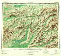
(10)- 1945 Map of Livengood
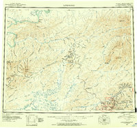 1945 Livengood1945 Print · USGSThe Alaska Interior at the end of World War II reveals a landscape of mining camps and river outposts. Trace the early road network from Chatanika to the gold fields of Livengood, or locate the site of Fort Hamlin.4 unique versions available
 - 1951 Map of Livengood, 1952 Print
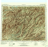 1951 Livengood1952 Print · USGSThe mining corridors of interior Alaska are mapped here during the early fifties, showing the vital links between the Yukon River and the mining camps. Trace early transport routes like the Steese Highway and Sled Roads to find places like Livengood, Chatanika, and Meehan.2 unique versions available
 - 1952 Map of Livengood A-2, 1972 Print
 1952 Livengood A-21972 Print · USGSMining camps and historical rail grades mark the Interior Alaska landscape in the early fifties. Genealogists and historians can trace the Old Railroad Grade past Olnes to specialized mining sites like Eldorado Camp and Pedro Camp.4 unique versions available
 - 1954 Map of Livengood A-2, 1955 Print
 1954 Livengood A-21955 Print · USGSThe interior of Alaska north of Fairbanks is shown here in the mid-fifties, still bearing the infrastructure of the gold rush. Genealogists and historians can trace the remnants of the Old Railroad Grade and locate mining hubs like Eldorado Camp and Old Chatanika.2 unique versions available
 - 1956 Map of Livengood, 1961 Print
 1956 Livengood1961 Print · USGSInterior Alaska during the mid-fifties reveals a landscape defined by gold mining camps and seasonal trails. You can trace the Railroad Grade and mining sites like Drew Mine or locate historic camps such as Chatanika and Pedro Camp.9 unique versions available
 - 1964 Map of Livengood
 1964 Livengood1964 Print · USGSInterior Alaska during the mid-sixties shows a land shaped by the gold mining industry and new road networks. Researchers can trace the path of the Davidson Ditch and locate historic mining camps such as Pedro Camp, Chatanika, and Golden City.
 - 1992 Map of Livengood A-2 SE
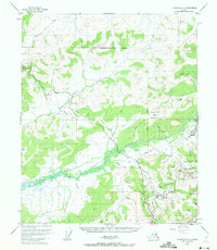
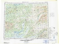
 1992 Livengood A-2 SE1992 Print · USGSThe Fairbanks North Star region is shown in the early nineties, illustrating a landscape shaped by gold mining and energy transport. Researchers can locate historic mining camps at Old Chatanika and Olnes, or trace the path of the Davidson Ditch and the Trans-Alaska Pipeline.
 - 2017 Map of Livengood A-2 SE, 2017 Print
 2017 Livengood A-2 SE2017 Print · USGSCovers Olnes, including Fairbanks North Star, United States, and other nearby areas
 - 2021 Map of Livengood A-2 SE, 2021 Print
 2021 Livengood A-2 SE2021 Print · USGSCovers Olnes, including Fairbanks North Star, United States, and other nearby areas
 - 2024 Map of Livengood A-2 SE, 2024 Print
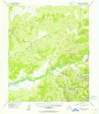
 2024 Livengood A-2 SE2024 Print · USGSThe gold-mining country north of Fairbanks is shown here in the mid-2020s, highlighting the industrial transition from old camps to modern infrastructure. Researchers can locate the Stark Airstrip, trace the path of the Alaska Pipeline, and explore the roads around Olnes.
End of results
Showing maps 1-10 of 10
Top cities near Olnes
Frequently asked questions
- What are the different types of historical maps available for Olnes?
- What is the oldest map of Olnes?
- Where can I purchase historical maps of Olnes for my home or office?
- Where can I download high-res historical maps of Olnes?
- Are there historical topographic maps available for Olnes?
- Is there historical aerial imagery available for Olnes?
- Where are historical maps of Olnes sourced from?