Old Maps of Beluga, Alaska for Genealogy
Trace your family roots with 6 historic maps of Beluga. These high-res maps reveal old neighborhoods, homesites, landmarks, and streets — helping you uncover where your ancestors lived and how the area evolved over time.
- Explore historic neighborhoods: Identify where your relatives may have lived in the 1800s or 1900s.
- Compare maps over time: Trace the changes in streets, buildings, and landmarks for multi-generational research.
- Perfect for genealogy & ancestry research: Used by family historians and researchers to map out lineage and migration.
These maps are an incredible resource for exploring your personal connection to Beluga's past.
Beluga, AK maps
(6)- 1949 Map of Tyonek, 1954 Print
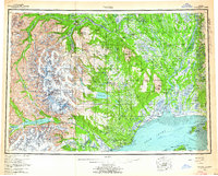
 1949 Tyonek1954 Print · USGSUpper Cook Inlet and the Alaska Range appear here in the mid-twentieth century as a landscape of massive glaciers and river-bound outposts. Researchers can trace the early rail corridor through Willow, locate the Moquawkie Indian Reservation, and find the site of McDougall.2 unique versions available
 - 1951 Map of Tyonek
 1951 Tyonek1951 Print · USGSThe Cook Inlet and the Alaska Range come into focus in the early fifties as the region's rail and trail networks evolved. Trace the path of the Alaska Railroad through Willow or locate the historic Iditarod Trail near Susitna.
 - 1958 Map of Tyonek A-3, 1961 Print
 1958 Tyonek A-31961 Print · USGSThe western shores of Cook Inlet appear in the mid-twentieth century as a network of expansive river deltas and seasonal settlements. Researchers can trace land use patterns near the Moquawkie (Tyonek) Indian Reservation and identify remote landmarks like Grants Beacon and the Winter Airstrip.3 unique versions available
 - 1958 Map of Tyonek, 1964 Print
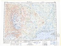
 1958 Tyonek1964 Print · USGSUpper Cook Inlet and the Susitna River valley are shown in the late fifties, capturing a period of transition between coastal village life and inland development. Researchers can trace the Winter Trail and Tractor Trail paths to settlements like Alexander and Susitna.6 unique versions available
 - 1965 Map of Tyonek
 1965 Tyonek1965 Print · USGSUpper Cook Inlet in the mid-sixties reveals a landscape defined by massive glaciers and the early footprints of coastal settlements. Trace the rail-and-river network from The Alaska Railroad to isolated outposts like Old Tyonek, Ladd, and the Moquawkie (Tyonek) Indian Reservation.
 - 2016 Map of Tyonek A-3 NW, 2016 Print
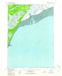
 2016 Tyonek A-3 NW2016 Print · USGSThe Kenai Peninsula coastline near the borough boundary shows a unique blend of wilderness and aviation-based settlement in 2016. Trace the remote roads around Beluga Airport and local landmarks like Cottonwood Beach or Dead Moose Drive.
End of results
Showing maps 1-6 of 6
Frequently asked questions
- What are the different types of historical maps available for Beluga?
- What is the oldest map of Beluga?
- Where can I purchase historical maps of Beluga for my home or office?
- Where can I download high-res historical maps of Beluga?
- Are there historical topographic maps available for Beluga?
- Is there historical aerial imagery available for Beluga?
- Where are historical maps of Beluga sourced from?