Old Maps of Iniskin, Alaska for Hiking & Exploration
Hike through history with 5 historic maps of Iniskin. Explore old trails, ghost towns, and forgotten backroads — perfect for outdoor adventurers and local explorers.
- Rediscover forgotten places: Map out old mining camps, roads, and footpaths that no longer exist on modern maps.
- Layer with modern tools: Combine with LiDAR or satellite views to plan hikes through historical terrain.
- Made for exploration: Popular among hikers, overlanders, and local history lovers.
Use these maps to find adventure and explore the hidden past of Iniskin.
Iniskin, AK maps
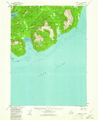
(5)- 1949 Map of Iliamna C-1
 1949 Iliamna C-11949 Print · USGSThe remote coast of the Kenai Peninsula is documented here in the late 1940s, showing a wild landscape of jagged peaks and deep bays. Researchers can trace the maritime features of Cook Inlet and find landmarks like Mt Pomeroy and Oil Point.
 - 1952 Map of Iliamna, 1953 Print
 1952 Iliamna1953 Print · USGSAlaska's interior and coastline meet in this early 1950s survey of the Lake Iliamna region. Researchers can trace remote settlements and camps such as Fish Village, Old Iliamna (Aband), and Hammerly Camp at the edge of the Katmai National Monument.4 unique versions available
 - 1957 Map of Iliamna, 1965 Print
 1957 Iliamna1965 Print · USGSSouthwestern Alaska in the late fifties centers on the massive waters of Iliamna Lake and its surrounding villages. Trace family roots and old routes at Old Roadhouse, Newhalen, and the Kamishak (Site) near the edge of Katmai National Monument.7 unique versions available
 - 1958 Map of Iliamna C-1, 1961 Print
 1958 Iliamna C-11961 Print · USGSThe western shores of Cook Inlet appear during a period of mid-century industrial exploration on the Kenai Peninsula. Researchers can trace the early infrastructure of the oil industry at Iniskin Well, locate the remote Airstrip, and follow the Tractor Trail through the wilderness.3 unique versions available
 - 2018 Map of Iliamna C-1 NW, 2018 Print
 2018 Iliamna C-1 NW2018 Print · USGSThe western Cook Inlet shoreline and the Iniskin Peninsula appear here in high detail during the late twenty-tens. Researchers can trace coastal landmarks like Oil Bay and Oil Point or locate summits such as Shark Tooth Hill and Mt Pomeroy.
End of results
Showing maps 1-5 of 5
Frequently asked questions
- What are the different types of historical maps available for Iniskin?
- What is the oldest map of Iniskin?
- Where can I purchase historical maps of Iniskin for my home or office?
- Where can I download high-res historical maps of Iniskin?
- Are there historical topographic maps available for Iniskin?
- Is there historical aerial imagery available for Iniskin?
- Where are historical maps of Iniskin sourced from?