
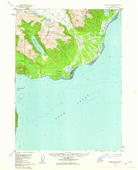
1949 Map of Iliamna C-1
USGS Topo · Published 1949About this map
Cook Inlet defines the coastal character of this remote Alaskan terrain, where the rugged shoreline of the Kenai Peninsula meets the waters of Oil Bay and Dry Bay. Mapped through reconnaissance topography by the Geological Survey and Corps of Engineers, the landscape is marked by sharp elevations including Shark Tooth and Mt Pomeroy. The lack of established roads or settlements in the late 1940s highlights the isolation of this region, which was instead defined by its maritime landmarks like Oil Point, Chinitna Point, and the hazardous Oil Reef. Inland, the drainage network of Portage Creek and Fitz Creek cuts through the high ground of Front Mtn and Bald Hill, illustrating the complex coastal watershed before modern development.
Find a feature on this map
22 named features on this map. Tap any name to fly to it.
Don’t see what you’re looking for? This feature index may not catch every label — zoom into the map to look around manually.
Map Details
Editions of this 1949 Iliamna C-1 Map
This is the sole edition of this map. No revisions or reprints were ever made.
Other maps of this area

1951 · Seldovia
USGS Topo · 1:250,000

1952 · Iliamna
USGS Topo · 1:250,000

1957 · Iliamna
USGS Topo · 1:250,000

1958 · Iliamna D-2
USGS Topo · 1:63,360

1958 · Iliamna C-2
USGS Topo · 1:63,360

1958 · Iliamna D-1
USGS Topo · 1:63,360

1958 · Iliamna B-2
USGS Topo · 1:63,360

1958 · Iliamna C-1
USGS Topo · 1:63,360
1958 · Seldovia D-8
USGS Topo · 1:63,360

1963 · Seldovia
USGS Topo · 1:250,000