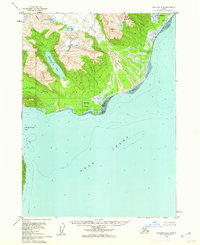
1958 Map of Seldovia D-8
USGS Topo · Published 1962About this map
Red River and the massive Red Glacier dominate this coastal wilderness on the western shore of Cook Inlet during the late 1950s. The landscape is defined by the transition from high peaks like Saddle Mountain and Lenore Hill down to the tidal flats of Chinitna Bay. While the area is largely uninhabited, small signs of activity appear near the northern shoreline, where a Sawmill and a Cabin are situated near Silver Salmon Lakes.
Find a feature on this map
21 named features on this map. Tap any name to fly to it.
Don’t see what you’re looking for? This feature index may not catch every label — zoom into the map to look around manually.
Map Details
Editions of this 1958 Seldovia D-8 Map
3 editions found
Other maps of this area

1944 · Kenai
USGS Topo · 1:250,000

1946 · Lake Clark
USGS Topo · 1:250,000

1949 · Iliamna C-1
USGS Topo · 1:63,360

1950 · Kenai
USGS Topo · 1:250,000

1951 · Lake Clark
USGS Topo · 1:250,000

1951 · Seldovia
USGS Topo · 1:250,000

1952 · Iliamna
USGS Topo · 1:250,000

1957 · Iliamna
USGS Topo · 1:250,000

1958 · Iliamna D-1
USGS Topo · 1:63,360

1958 · Iliamna C-1
USGS Topo · 1:63,360