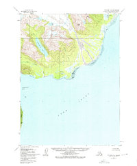
1958 Map of Seldovia D-8
USGS Topo · Published 1976About this map
The Iniskin Peninsula meets the northern waters of Cook Inlet in this mid-century topographic record of the Kenai Peninsula Borough coastline. The landscape is dominated by the massive Red Glacier, which feeds the Red River as it flows toward extensive Tidal Flats on the eastern shore. Signs of early industrial and wilderness habitation appear at a lone Sawmill and scattered Cabin sites, indicating the small-scale timber and trapping activity common in this era.
Find a feature on this map
23 named features on this map. Tap any name to fly to it.
Don’t see what you’re looking for? This feature index may not catch every label — zoom into the map to look around manually.
Map Details
Editions of this 1958 Seldovia D-8 Map
3 editions found
Other maps of this area

1944 · Kenai
USGS Topo · 1:250,000

1946 · Lake Clark
USGS Topo · 1:250,000

1949 · Iliamna C-1
USGS Topo · 1:63,360

1950 · Kenai
USGS Topo · 1:250,000

1951 · Lake Clark
USGS Topo · 1:250,000

1951 · Seldovia
USGS Topo · 1:250,000

1952 · Iliamna
USGS Topo · 1:250,000

1957 · Iliamna
USGS Topo · 1:250,000

1958 · Iliamna D-1
USGS Topo · 1:63,360

1958 · Iliamna C-1
USGS Topo · 1:63,360