Old Maps of Kasilof, Alaska for Academic Research
Study the evolution of Kasilof with 8 high-resolution historic maps. Whether you're teaching, researching, or modeling changes in land use, these maps provide essential visual documentation of urban, environmental, and geographic change.
- Analyze long-term change: Track patterns in development, transportation, and natural features.
- Ideal for environmental or urban studies: Support academic projects with primary historical map data.
- Use in the classroom or lab: Educators and researchers rely on these maps to bring historical context to life.
These maps are a powerful tool for teaching, research, and visualizing how Kasilof has changed over the decades.
Kasilof, AK maps
(8)- 1944 Map of Kenai, 1954 Print
 1944 Kenai1954 Print · USGSThe Kenai Peninsula and Cook Inlet are captured here during a period of postwar growth, just as the regional road system began to expand. Genealogists and historians can trace early settlements and family landmarks such as Salamatoff, Stelters Ranch, and the Snug Harbor Cannery.4 unique versions available
 - 1950 Map of Kenai
 1950 Kenai1950 Print · USGSThe Kenai Peninsula and Cook Inlet appear here during a pivotal era of mid-century growth and road construction. Researchers can trace the early layout of Soldotna, locate the Snug Harbor Cannery, and see the footprint of Salamatof.2 unique versions available
 - 1951 Map of Kenai B-4, 1967 Print
 1951 Kenai B-41967 Print · USGSThe Kenai Peninsula coastline at the start of the 1950s shows a landscape of fishing settlements and early industrial expansion. Trace the growth of Kalifonsky and Cohoe, or locate historic Gas Wells and the remote Kasilof Landing Strip.2 unique versions available
 - 1952 Map of Kenai B-4, 1954 Print
 1952 Kenai B-41954 Print · USGSThe Kenai Peninsula coastline near Kasilof was a rugged frontier of fishing and homesteading in the early fifties. Genealogists and local historians can trace early settlements at Cohoe, remote Cabins, and the navigation markers at Hongkong Bend.3 unique versions available
 - 1958 Map of Kenai, 1967 Print
 1958 Kenai1967 Print · USGSThe Kenai Peninsula and Cook Inlet are captured here during a period of mid-century growth and wilderness management. Researchers can trace early settlements and infrastructure like Nikishka No 1, Salamatof, and the Wildwood Military Reservation.6 unique versions available
 - 1986 Map of Kenai B-4 SE
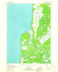
 1986 Kenai B-4 SE1986 Print · USGSThe Kasilof River corridor in the mid-1980s is captured here, showing the balance between early settlement and the vast Kenai National Wildlife Refuge. Genealogists and historians can trace locations around Kasilof, identify local boat ramps, and locate early infrastructure like the Winter Trail.
 - 2014 Map of Kenai B-4 SE, 2014 Print
 2014 Kenai B-4 SE2014 Print · USGSCovers Kasilof, including Cohoe, Kenai Peninsula, and other nearby areas
 - 2024 Map of Kenai B-4 SE, 2024 Print
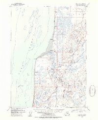
 2024 Kenai B-4 SE2024 Print · USGSThe Kenai Peninsula coastline and riverbanks are captured in this contemporary survey of the settlements between the Sterling Highway and the Cook Inlet. Researchers can locate the Spruce Grove Memorial Cem and trace the winding Kasilof River through Moosehead Rapids and Hongkong Bend.
End of results
Showing maps 1-8 of 8
Top cities near Kasilof
Frequently asked questions
- What are the different types of historical maps available for Kasilof?
- What is the oldest map of Kasilof?
- Where can I purchase historical maps of Kasilof for my home or office?
- Where can I download high-res historical maps of Kasilof?
- Are there historical topographic maps available for Kasilof?
- Is there historical aerial imagery available for Kasilof?
- Where are historical maps of Kasilof sourced from?