Old Maps of Lakeview, Alaska for Metal Detecting
Plan your next treasure hunt with 9 historic maps of Lakeview. Find old homesites, ghost towns, trails, and gathering spots that may be lost to time — perfect for identifying promising metal detecting locations.
- Locate forgotten sites: Uncover places like long-lost settlements, abandoned rail lines, or gathering spots.
- Plan better hunts: Use map overlays combined with LiDAR or satellite views to narrow in on historically rich areas.
- Made for detectorists: Thousands of hobbyists use these maps to discover relics, coins, and hidden history.
Use these historic maps to boost your research and find new opportunities beneath the surface of Lakeview.
Lakeview, AK maps
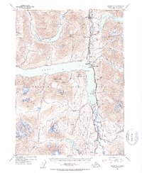
(9)- 1951 Map of Seward
 1951 Seward1951 Print · USGSThe Kenai Peninsula and Prince William Sound come to life in the early 1950s as the rail and maritime networks linked remote coastal outposts. Genealogists and historians can trace the Alaska Railroad corridor through Seward, find the Jesse Lee Indian School, and locate isolated camps like Latouche and Chenega.4 unique versions available
 - 1951 Map of Seward B-7, 1960 Print
 1951 Seward B-71960 Print · USGSThe Kenai Peninsula during the early fifties reveals a landscape of high-altitude mines and isolated rail stops along the Alaska Railroad. Genealogists and historians can locate the Minnie Andacher Homestead and trace operations at the Crown Point Mine and Primrose Mine.4 unique versions available
 - 1953 Map of Seward B-7, 1954 Print
 1953 Seward B-71954 Print · USGSThe Kenai Peninsula in the mid-fifties shows a landscape of mountain mining and early highway development. Genealogists and historians can trace the Minnie Andacher Homestead, explore the Crown Point Mine, or follow the Alaska Railroad through Moose Pass.2 unique versions available
 - 1953 Map of Seward, 1956 Print
 1953 Seward1956 Print · USGSThe Kenai Peninsula and Prince William Sound are documented in the early 1950s as the rail and road networks expanded. Trace the route of the Alaska Railroad and find early settlements like Seward, Moose Pass, and Latouche.12 unique versions available
 - 1959 Map of Seward
 1959 Seward1959 Print · USGSThe Kenai Peninsula and Prince William Sound are captured here during the mid-century, showing the vital transit corridor between Seward and the interior. Researchers can trace the Alaska Railroad through Whittier and locate historic coastal settlements like Chenega and Latouche.
 - 1983 Map of Seward B-7 SE
 1983 Seward B-7 SE1983 Print · USGSThe Kenai Peninsula's interior wilderness is captured in the early 1980s as it transitions from the shores of Kenai Lake to the peaks of Sheep Mountain. Researchers can trace the path of the Snow River and locate remote spots like Lakeview, Divide, and Lost Lake.
 - 1994 Map of Seward B-7, 1998 Print
 1994 Seward B-71998 Print · USGSThe Kenai Peninsula's interior wilderness shows a mix of industrial history and recreation in the 1990s as the rail line skirts massive lakes. Researchers can locate the Minnie-Andacher Homestead and historic extraction sites like Solars Sawmill (Aband) and Primrose Mine.
 - 2018 Map of Seward B-7 SE, 2018 Print
 2018 Seward B-7 SE2018 Print · USGSCovers Lakeview, including Primrose, Kenai Peninsula, and other nearby areas
 - 2023 Map of Seward B-7 SE, 2023 Print
 2023 Seward B-7 SE2023 Print · USGSThe Kenai Peninsula's interior corridor appears here in the early twenty-first century, centered on the glacial waters of Kenai Lake. You can trace the historical path of the Iditarod National Historic Trl as it weaves past Lakeview and the Snow River.
End of results
Showing maps 1-9 of 9
Top cities near Lakeview
Frequently asked questions
- What are the different types of historical maps available for Lakeview?
- What is the oldest map of Lakeview?
- Where can I purchase historical maps of Lakeview for my home or office?
- Where can I download high-res historical maps of Lakeview?
- Are there historical topographic maps available for Lakeview?
- Is there historical aerial imagery available for Lakeview?
- Where are historical maps of Lakeview sourced from?