1900s (20th Century) Maps of Stepanka's Village, Alaska
Explore 6 historic maps of Stepanka's Village from the 1900s (20th Century). These maps offer a rare glimpse into what life looked like during the 1900s — showing old roads, neighborhoods, homes, and landmarks that have changed or disappeared over time.
Whether you're researching your family's past, planning a metal detecting trip, or studying how Stepanka's Village's landscape evolved across the 1900s, these high-resolution maps are a powerful tool for exploring the history of this region.
- Focus on a specific era: All maps on this page are from the 1900s, giving you a focused view of this time period.
- See what’s changed: Compare century-old streets, trails, and buildings to today's modern landscape using overlays and satellite layers.
- Research with precision: Use these maps for genealogy, historical research, land use analysis, or educational projects.
- View, download, or print: Maps are fully viewable online in high resolution, and can be downloaded or printed for your own records.
Start exploring Stepanka's Village's history through authentic maps from the 1900s. This is your window into the past.
Stepanka's Village, AK maps
(6)- 1944 Map of Kenai, 1954 Print
 1944 Kenai1954 Print · USGSThe Kenai Peninsula and Cook Inlet are captured here during a period of postwar growth, just as the regional road system began to expand. Genealogists and historians can trace early settlements and family landmarks such as Salamatoff, Stelters Ranch, and the Snug Harbor Cannery.4 unique versions available
 - 1950 Map of Kenai
 1950 Kenai1950 Print · USGSThe Kenai Peninsula and Cook Inlet appear here during a pivotal era of mid-century growth and road construction. Researchers can trace the early layout of Soldotna, locate the Snug Harbor Cannery, and see the footprint of Salamatof.2 unique versions available
 - 1951 Map of Kenai B-2, 1960 Print
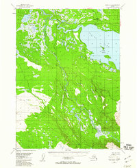 1951 Kenai B-21960 Print · USGSThe Kenai Peninsula in the early fifties remains a vast frontier of braided rivers and federal wildlife territory. Trace early human footprints through scattered Cabins, the Skilak Guard Station, and the winding Funny River.5 unique versions available
 - 1952 Map of Kenai B-2, 1954 Print
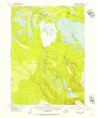 1952 Kenai B-21954 Print · USGSThe Kenai Peninsula in the early fifties remains a largely untouched wilderness within the Kenai National Moose Range. You can trace early backcountry travel along the Sterling Highway and locate isolated Cabins near Skilak Lake.2 unique versions available
 - 1958 Map of Kenai, 1967 Print
 1958 Kenai1967 Print · USGSThe Kenai Peninsula and Cook Inlet are captured here during a period of mid-century growth and wilderness management. Researchers can trace early settlements and infrastructure like Nikishka No 1, Salamatof, and the Wildwood Military Reservation.6 unique versions available
 - 1986 Map of Kenai B-2 NW
 1986 Kenai B-2 NW1986 Print · USGSThe Kenai Peninsula's interior remains a sprawling expanse of wetlands and rivers in the mid-1980s. Researchers can trace the complex waterways of the Kenai River and Upper Killey River alongside remote sites like Browns Lake.
End of results
Showing maps 1-6 of 6
Frequently asked questions
- What are the different types of historical maps available for Stepanka's Village?
- What is the oldest map of Stepanka's Village?
- Where can I purchase historical maps of Stepanka's Village for my home or office?
- Where can I download high-res historical maps of Stepanka's Village?
- Are there historical topographic maps available for Stepanka's Village?
- Is there historical aerial imagery available for Stepanka's Village?
- Where are historical maps of Stepanka's Village sourced from?