Old Maps of Port O'Brien, Alaska for Genealogy
Trace your family roots with 4 historic maps of Port O'Brien. These high-res maps reveal old neighborhoods, homesites, landmarks, and streets — helping you uncover where your ancestors lived and how the area evolved over time.
- Explore historic neighborhoods: Identify where your relatives may have lived in the 1800s or 1900s.
- Compare maps over time: Trace the changes in streets, buildings, and landmarks for multi-generational research.
- Perfect for genealogy & ancestry research: Used by family historians and researchers to map out lineage and migration.
These maps are an incredible resource for exploring your personal connection to Port O'Brien's past.
Port O'Brien, AK maps
(4)- 1952 Map of Kodiak, 1953 Print
 1952 Kodiak1953 Print · USGSKodiak Island in the early fifties shows a landscape of strategic military bases and coastal fishing villages. Researchers can trace the layout of the Naval Reservation, the whaling station at Port Hobron, and remote settlements like Old Harbor.12 unique versions available
 - 1952 Map of Kodiak C-4, 1966 Print
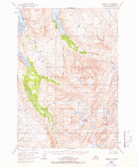 1952 Kodiak C-41966 Print · USGSKodiak Island in the early fifties is shown here as a landscape of deep fjords and isolated outposts. Researchers can trace the coastal operations at Port O'Brien or locate remote landmarks like the Gaging Sta and Mount Glottof.4 unique versions available
 - 1954 Map of Kodiak C-4, 1955 Print
 1954 Kodiak C-41955 Print · USGSKodiak Island in the early fifties remains a landscape of deep fjords and isolated outposts within a newly established wildlife refuge. Researchers can locate remote coastal sites like Port O'Brien, trace the Uganik River to Uganik Lake, and find a lonely Cabin on the bay.
 - 2021 Map of Kodiak C-4 NW, 2021 Print
 2021 Kodiak C-4 NW2021 Print · USGSKodiak Island's maritime landscape is captured in this recent survey, showcasing the remote coastal settlement of Port O'Brien. Researchers can trace the drainage of Uganik Lake and the rugged shoreline from Terror Bay to Sheep Island.
End of results
Showing maps 1-4 of 4
Frequently asked questions
- What are the different types of historical maps available for Port O'Brien?
- What is the oldest map of Port O'Brien?
- Where can I purchase historical maps of Port O'Brien for my home or office?
- Where can I download high-res historical maps of Port O'Brien?
- Are there historical topographic maps available for Port O'Brien?
- Is there historical aerial imagery available for Port O'Brien?
- Where are historical maps of Port O'Brien sourced from?