Old Maps of Chignik Lake, Alaska for Genealogy
Trace your family roots with 3 historic maps of Chignik Lake. These high-res maps reveal old neighborhoods, homesites, landmarks, and streets — helping you uncover where your ancestors lived and how the area evolved over time.
- Explore historic neighborhoods: Identify where your relatives may have lived in the 1800s or 1900s.
- Compare maps over time: Trace the changes in streets, buildings, and landmarks for multi-generational research.
- Perfect for genealogy & ancestry research: Used by family historians and researchers to map out lineage and migration.
These maps are an incredible resource for exploring your personal connection to Chignik Lake's past.
Chignik Lake, AK maps
(3)- 1963 Map of Chignik B-3, 1967 Print
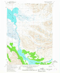 1963 Chignik B-31967 Print · USGSThe Alaska Peninsula in the early sixties is documented here as a landscape of vast river systems and glacial lakes. Researchers can trace the winding paths of the Alec River and Chignik River or locate the headwaters of Cucumber Creek.2 unique versions available
 - 1963 Map of Chignik, 1968 Print
 1963 Chignik1968 Print · USGSThe Alaska Peninsula in the mid-sixties is a world of volcanic peaks and isolated fishing outposts. Genealogists and historians can trace the foundations of Chignik and Meshik or locate remote Cabins near Chignik Lake and the Meshik River.3 unique versions available
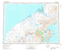
 - 2020 Map of Chignik B-3 SE, 2020 Print
 2020 Chignik B-3 SE2020 Print · USGSThe Alaska Peninsula at the turn of the decade shows the remote settlement of Chignik Lake and its vital transport links. Researchers can trace local landmarks like the Chignik Lake Graveyard, the Chignik Lake Airport, and the course of the Chignik River.
End of results
Showing maps 1-3 of 3
Frequently asked questions
- What are the different types of historical maps available for Chignik Lake?
- What is the oldest map of Chignik Lake?
- Where can I purchase historical maps of Chignik Lake for my home or office?
- Where can I download high-res historical maps of Chignik Lake?
- Are there historical topographic maps available for Chignik Lake?
- Is there historical aerial imagery available for Chignik Lake?
- Where are historical maps of Chignik Lake sourced from?